Munchon
| Munch'ŏn 문천시 | |
|---|---|
| Municipal City | |
| Korean transcription(s) | |
| • Chosŏn'gŭl | 문천시 |
| • Hancha | 文川市 |
| • McCune-Reischauer | Munch'ŏn si |
| • Revised Romanization | Muncheon-si |
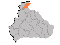 Map of Kangwon showing the location of Munch'ŏn | |
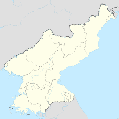 Munch'ŏn Map of North Korea showing the location of Munch'ŏn | |
| Coordinates: 39°15′32″N 127°21′22″E / 39.259°N 127.356°ECoordinates: 39°15′32″N 127°21′22″E / 39.259°N 127.356°E | |
| Country | North Korea |
| Province | Kangwon Province |
| Climate | Dwa |
Munch'ŏn (Korean pronunciation: [mun.tsʰʌn]) is a North Korean city located in Kangwŏn Province. It lies on the coast of the Sea of Japan (East Sea of Korea) and borders Wonsan.
Geography
Munch'ŏn sits on Yŏnghŭng Bay, a bay of the Sea of Japan, on lowland seacoast terrain. The Masingryŏng Mountain Range is to the southwest. The Sokko Mountain Range and Ch'ŏllyŏng Mountain Range are also located here, and Kulttuk Peak is the highest mountain in the region. The main river is the Namch'ŏn River.
Climate
Munch'ŏn has a humid continental climate (Köppen climate classification: Dwa).
| Climate data for Munch'ŏn | |||||||||||||
|---|---|---|---|---|---|---|---|---|---|---|---|---|---|
| Month | Jan | Feb | Mar | Apr | May | Jun | Jul | Aug | Sep | Oct | Nov | Dec | Year |
| Average high °C (°F) | 1.3 (34.3) |
2.4 (36.3) |
7.6 (45.7) |
15.9 (60.6) |
20.9 (69.6) |
24.3 (75.7) |
27.2 (81) |
27.9 (82.2) |
24.0 (75.2) |
18.9 (66) |
10.4 (50.7) |
3.1 (37.6) |
15.3 (59.6) |
| Daily mean °C (°F) | −3.9 (25) |
−2.4 (27.7) |
2.8 (37) |
10.1 (50.2) |
15.3 (59.5) |
19.6 (67.3) |
23.3 (73.9) |
23.8 (74.8) |
19.0 (66.2) |
13.2 (55.8) |
5.6 (42.1) |
−1.3 (29.7) |
10.4 (50.8) |
| Average low °C (°F) | −9.0 (15.8) |
−7.2 (19) |
−1.9 (28.6) |
4.4 (39.9) |
9.8 (49.6) |
15.0 (59) |
19.4 (66.9) |
19.8 (67.6) |
14.1 (57.4) |
7.5 (45.5) |
0.9 (33.6) |
−5.7 (21.7) |
5.6 (42.1) |
| Average precipitation mm (inches) | 27 (1.06) |
28 (1.1) |
48 (1.89) |
64 (2.52) |
75 (2.95) |
125 (4.92) |
348 (13.7) |
365 (14.37) |
235 (9.25) |
57 (2.24) |
54 (2.13) |
24 (0.94) |
1,450 (57.07) |
| Source: Climate-Data.org [1] | |||||||||||||
Administrative divisions
Munch'ŏn is divided into 16 tong and 14 ri:
|
|
Economy
Agriculture and fishery
Fishery, fruit, and livestock are the main industries of the region. Grain is the main agricultural product.
Mining
Munch'ŏn has reserves of zinc, gold, silver, limestone, dolomite, granite and clay. Anthracite is also produced.
Transportation
Munch'ŏn-si is served by the Kangwŏn Line of the Korean State Railway, with stations at Koam-dong, Okp'yŏng-dong and Munch'ŏn-dong.
References
- ↑ "Climate: Munch'ŏn". Climate-Data.org. Retrieved July 27, 2018.
Further reading
- Dormels, Rainer. North Korea's Cities: Industrial facilities, internal structures and typification. Jimoondang, 2014. ISBN 978-89-6297-167-5
External links
- (in Korean) In Korean language online encyclopedias:
- Korea Tourist Map (English, Korean, Japanese, Chinese)
- City profile of Munchon