Hoeryong
| Hoeryong 회령시 | |
|---|---|
| Municipal City | |
| Korean transcription(s) | |
| • Chosŏn'gŭl | 회령시 |
| • Hancha | 會寧市 |
| • McCune-Reischauer | Hoeryŏng-si |
| • Revised Romanization | Hoeryeong-si |
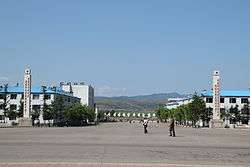 Hoeryong City Centre | |
|
| |
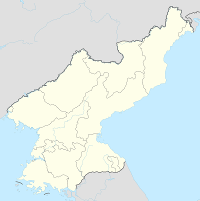 Hoeryong Map of North Korea showing the location of Hoeryong | |
| Coordinates: 42°26′N 129°45′E / 42.433°N 129.750°ECoordinates: 42°26′N 129°45′E / 42.433°N 129.750°E | |
| Country | North Korea |
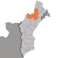
| Province | North Hamgyong Province |
| Population | |
| • Total | 134,524 |
Hoeryŏng (Korean pronunciation: [hø.ɾjʌŋ]) is a city in North Hamgyŏng Province, North Korea. It is located opposite Jilin Province, China, with the Tumen River in between. Sanhe (三合鎮), in Longjing City, is the closest Chinese town across the river. Hoeryŏng is claimed to be the birthplace of Kim Il Sung's first wife and Kim Jong Il's mother, Kim Jong Suk.[1] The Hoeryong Revolutionary Site commemorates the birthplace.[2]
The Hoeryŏng concentration camp (Kwalliso No. 22) is located 20 kilometres (12 mi) from the city.[3]

History
Hoeryŏng was one of the six post/garrisons (Chosŏngŭl: 육진, Hanja: 六鎭) established under the order of Sejong the Great of Joseon (1418 - 1450) to safeguard his people from the potentially hostile semi-nomadic Jurchens living north of the Yalu river.
In early May 2007, the newly appointed Prime Minister Kim Yong-il visited Hoeryŏng. At the time, the Prime Minister brought with him on his train, one carriage worth of glass (made in South Korea) and 3 carriages worth of cement. After delivering the goods to the People’s Committee of Hoeryŏng he ordered that the city of Hoeryŏng be decorated and adorned as much as a city where Mother Kim Jong Suk’s birthplace should be.
Administrative divisions
Hoeryŏng-si is divided into 19 tong (neighbourhoods) and 28 ri (villages):
|
|
Economy
Hoeryŏng's main industries are mining machines and a paper mill. The area contains many mines. According to media reports, in 2017 ordinary residents in Hoeryong receive electricity for 3–4 hours per day.[4]
Civil unrest
It is reported that on 24 September 2008 only about 20% of Hoeryŏng's city residents attended a civilian defence-training programme held in Hoeryŏng City. The other 80% are thought to have stayed home or tended to private patch fields. As punishment, authorities from the Civilian Defence ordered non-attendees to pay KP₩5,000, however this fine was largely ignored.[5]
Climate
Hoeryong has a humid continental climate (Köppen climate classification: Dwb).
| Climate data for Hoeryong | |||||||||||||
|---|---|---|---|---|---|---|---|---|---|---|---|---|---|
| Month | Jan | Feb | Mar | Apr | May | Jun | Jul | Aug | Sep | Oct | Nov | Dec | Year |
| Average high °C (°F) | −5.1 (22.8) |
−2.0 (28.4) |
4.2 (39.6) |
12.6 (54.7) |
18.3 (64.9) |
21.4 (70.5) |
24.8 (76.6) |
25.4 (77.7) |
21.2 (70.2) |
14.7 (58.5) |
4.9 (40.8) |
−2.7 (27.1) |
11.5 (52.7) |
| Daily mean °C (°F) | −11.1 (12) |
−8.5 (16.7) |
−2.2 (28) |
5.7 (42.3) |
11.4 (52.5) |
16.0 (60.8) |
20.3 (68.5) |
20.8 (69.4) |
15.3 (59.5) |
8.1 (46.6) |
−0.8 (30.6) |
−8.4 (16.9) |
5.6 (42) |
| Average low °C (°F) | −17.0 (1.4) |
−15.0 (5) |
−8.5 (16.7) |
−1.2 (29.8) |
4.6 (40.3) |
10.7 (51.3) |
15.8 (60.4) |
16.3 (61.3) |
9.4 (48.9) |
1.5 (34.7) |
−6.4 (20.5) |
−14.0 (6.8) |
−0.3 (31.4) |
| Average precipitation mm (inches) | 6 (0.24) |
6 (0.24) |
14 (0.55) |
29 (1.14) |
61 (2.4) |
94 (3.7) |
112 (4.41) |
155 (6.1) |
82 (3.23) |
38 (1.5) |
20 (0.79) |
8 (0.31) |
625 (24.61) |
| Source: Climate-Data.org[6] | |||||||||||||
See also
Notes
- ↑ "Brilliant life of Kim Jong Suk". KCNA. Archived from the original on 2005-03-16. Retrieved 2006-06-28.
- ↑ "Hoeryong Revolutionary Site". KCNA. 14 December 2011. Archived from the original on 12 October 2014.
- ↑ "Kwan-li-so No.22 Haengyŏng (Hoeryŏng)". Wikimapia. Retrieved June 18, 2012.
- ↑ Shim, Elizabeth (July 12, 2017). "North Korea supplies high-voltage electricity to border fence". UPI.
Ordinary North Koreans in Hoeryong, North Hamgyong Province, on the other hand, are supplied with electricity for about 3 to 4 hours a day, the North Korean source said.
- ↑ North Korea Today, No. 28. (2008). Research Institute for North Korean society.
- ↑ "Climate: Hoeryong - Climate-Data.org". Retrieved 25 July 2018.
Further reading
- Dormels, Rainer. North Korea's Cities: Industrial facilities, internal structures and typification. Jimoondang, 2014. ISBN 978-89-6297-167-5
External links
| Wikimedia Commons has media related to Hoeryong. |
- Hoeryong City picture album at Naenara
- Location of the four forts and the six posts
- (in Korean) In Korean language online encyclopedias:
- City profile of Hoeryong
