Mount Tuzo
| Mount Tuzo | |
|---|---|
 Mount Tuzo | |
| Highest point | |
| Elevation | 3,248 m (10,656 ft) [1] |
| Prominence | 210 m (690 ft) |
| Coordinates | 51°18′06″N 116°13′42″W / 51.30167°N 116.22833°WCoordinates: 51°18′06″N 116°13′42″W / 51.30167°N 116.22833°W |
| Geography | |
 Mount Tuzo Location in Alberta | |
| Location | Alberta/British Columbia, Canada |
| Parent range | Valley of the Ten Peaks |
| Topo map | NTS 82N/08 |
| Climbing | |
| First ascent | 1906 H. Tuzo, C. Kaufmann |
| Easiest route | Peak 7 |
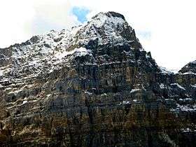
Mount Tuzo was named in 1907 after Henrietta L. Tuzo. It is located within the Valley of the Ten Peaks in the Canadian Rockies, along the Continental Divide, which forms the boundary between British Columbia and Alberta in this region.[2][3]
See also
References
This article is issued from
Wikipedia.
The text is licensed under Creative Commons - Attribution - Sharealike.
Additional terms may apply for the media files.