Mount Sir John Abbott
| Mount Sir John Abbott | |
|---|---|
 | |
| Highest point | |
| Elevation | 3,398 m (11,148 ft) [1] |
| Prominence | 593 m (1,946 ft) [1] |
| Listing | Mountains of British Columbia |
| Coordinates | 52°48′39″N 119°47′39″W / 52.81083°N 119.79417°WCoordinates: 52°48′39″N 119°47′39″W / 52.81083°N 119.79417°W [2] |
| Geography | |
 Mount Sir John Abbott Location in eastern British Columbia | |
| Location | British Columbia, Canada |
| Parent range | Premier Range |
| Topo map | NTS 83D/13 |
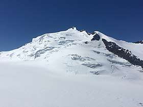
Mount Sir John Abbott is a 3,398 m (11,148 ft) mountain located in the Premier Range of the Cariboo Mountains in the east-central interior of British Columbia, Canada. It is located at the south end of the west wall of Kiwa Glacier, the source of Kiwa Creek.
The name honours the second Prime Minister of Canada, Sir John Abbott, who died in 1893. It was one of the first mountains in the Premier Range to be named after a Prime Minister, receiving its designation on September 6, 1927.[2] It was originally named Mount Kiwa.[1]
References
- 1 2 3 "Mount Sir John Abbott". Bivouac.com. Retrieved 2006-07-23.
- 1 2 "Mount Sir John Abbott". BC Geographical Names. Retrieved 2013-06-08.
External links
- Canadian Mountain Encyclopedia listing for Mount Sir John Abbott
This article is issued from
Wikipedia.
The text is licensed under Creative Commons - Attribution - Sharealike.
Additional terms may apply for the media files.