Snowpatch Spire
| Snowpatch Spire, The Bugaboos | |
|---|---|
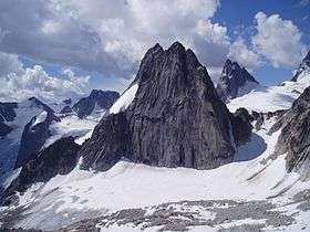 Snowpatch Spire, with Pigeon Spire in the background on the right, Hound's Tooth and Marmolata Spire on the left. | |
| Highest point | |
| Elevation | 3,084 m (10,118 ft) |
| Prominence | 284 m (932 ft) |
| Coordinates | 50°44′2″N 116°47′9″W / 50.73389°N 116.78583°W |
| Geography | |
| Location | British Columbia, Canada |
| Parent range | Purcell Mountains, East Kootenay |
| Topo map | NTS 82K/10 |
| Geology | |
| Mountain type | Granite |
| Climbing | |
| First ascent | August 1940 by Raffi Bedayan and Jack Arnold [1] |
| Easiest route | 5.6, long |
With its first ascent in 1940, Snowpatch Spire mountain peak was the last of the Bugaboo Spires to be climbed. It is located South-West of the Conrad Kain hut, across the Crescent Glacier.
Routes
- Wildflowers
- Kraus McCarthy
- Sunshine
- Surf's Up! (aka Southwest Ridge)
- Southeast Corner (aka Snowpatch Route)
Nearby
- Conrad Kain hut
- Bugaboo Spire
- Pigeon Spire
- Howser Spire
- Marmolata Spire
External links
- "Snowpatch Spire". Bivouac.com.
References
- ↑ Raffi Bedayan, A Bugaboo No Longer, American Alpine Journal Vol. 4, p. 219 (1941)
This article is issued from
Wikipedia.
The text is licensed under Creative Commons - Attribution - Sharealike.
Additional terms may apply for the media files.