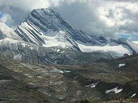
Mount Sir Douglas
| Mount Sir Douglas | |
|---|---|
 | |
| Highest point | |
| Elevation | 3,411 m (11,191 ft) [1] |
| Prominence | 1,110 m (3,640 ft) [1] |
| Coordinates | 50°43′20″N 115°20′20″W / 50.72222°N 115.33889°WCoordinates: 50°43′20″N 115°20′20″W / 50.72222°N 115.33889°W [1] |
| Geography | |
 Mount Sir Douglas | |
| Parent range | Canadian Rockies |
| Topo map | NTS 82J/11 |
| Climbing | |
| First ascent | 1919 J.W.A. Hickson and Edward Feuz Jr[2] |
| Easiest route | North-West Face III |
Mount Sir Douglas is located on the border of Alberta and British Columbia on the Continental Divide. It is Alberta's 18th highest peak, and 28th prominence mountain as well as British Columbia's 28th highest peak. It was named in 1916 after Field Marshal Sir Douglas Haig.[1][2]
See also
References
- 1 2 3 4 "Mount Sir Douglas". Bivouac.com. Retrieved 2010-02-14.
- 1 2 "Mount Sir Douglas". PeakFinder.com. Retrieved 2010-02-14.
This article is issued from
Wikipedia.
The text is licensed under Creative Commons - Attribution - Sharealike.
Additional terms may apply for the media files.