Mount Rae
| Mount Rae | |
|---|---|
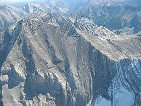 Mt. Rae from the north (Sept. 2006) | |
| Highest point | |
| Elevation | 3,218 m (10,558 ft) [1] |
| Prominence | 1,330 m (4,360 ft) [2] |
| Coordinates | 50°37′24″N 114°58′30″W / 50.62333°N 114.97500°WCoordinates: 50°37′24″N 114°58′30″W / 50.62333°N 114.97500°W [2] |
| Geography | |
 Mount Rae Location in Alberta | |
| Location | Alberta, Canada |
| Parent range | Misty Range |
| Topo map | NTS 82J/10 |
| Climbing | |
| Easiest route | Moderate scramble |
Mount Rae is a mountain located on the east side of Highway 40 between Elbow Pass and the Ptarmigan Cirque in the Canadian Rockies of Alberta. Mount Rae was named after John Rae, explorer of Northern Canada, in 1859.[3]
Due to its relatively high summit and modest elevation gain from Highwood Pass, Mount Rae is a very popular scrambling objective. The scramble starts at the Highwood Pass parking lot on Highway 40 (2,227 m (7,306 ft)) and proceeds to the back of the Ptarmigan Cirque. Two options from this point are either ascending a steep snow field or climbing progressively steeper slabs to the col. Once on the col (connecting the main summit of Rae with an unnamed peak), the route ascends on the northern side to the narrow summit ridge. In snowy conditions, sticking close to the summit ridge and passing an upcoming massive gendarme is the standard route. In dry conditions, the gendarme can be bypassed on slopes beneath it.
References
- ↑ "Mount Rae". PeakFinder.com. Retrieved 2007-08-31.
- 1 2 "Mount Rae". Bivouac.com. Retrieved 2009-01-02.
- ↑ Birrell, Dave (2000). 50 Roadside Panoramas in the Canadian Rockies (Google Books search). Rocky Mountain Books Ltd. p. 122. ISBN 978-0-921102-65-6. Retrieved 2017-01-29.
External links
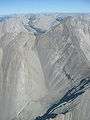 Mt. Rae from the South
 Mt. Rae (middle left) from Highwood Pass