Mount Liberty (New Hampshire)
| Mount Liberty | |
|---|---|
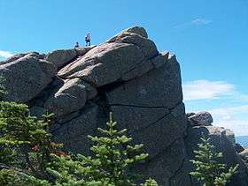 Summit of Mount Liberty | |
| Highest point | |
| Elevation | 4,459 ft (1,359 m) |
| Prominence | 379 ft (116 m) [1] |
| Listing | White Mountain 4000-Footers |
| Coordinates | 44°06′57″N 71°38′32″W / 44.115781°N 71.642142°WCoordinates: 44°06′57″N 71°38′32″W / 44.115781°N 71.642142°W |
| Geography | |
| Location | Grafton County, New Hampshire, U.S. |
| Parent range | Franconia Range |
| Climbing | |
| Easiest route | Hike |
Mount Liberty[1] is a 4,459-foot-high (1,359 m) mountain in the White Mountains of New Hampshire. Overlooking Franconia Notch, it is part of Franconia Ridge, the second highest mountain group in the Whites after the Presidential Range. It lies southwest of Mount Lafayette, the highest summit along the ridge, and is listed among the Appalachian Mountain Club's "four-thousand footers".
Gallery
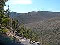 Mount Liberty seen from the slide on Owl's Head
See also
References
- 1 2 "Mount Liberty, New Hampshire". Peakbagger.com. Retrieved 2008-04-11.
This article is issued from
Wikipedia.
The text is licensed under Creative Commons - Attribution - Sharealike.
Additional terms may apply for the media files.