Mount Cottrell, Victoria
| Mount Cottrell Melbourne, Victoria | |||||||||||||||
|---|---|---|---|---|---|---|---|---|---|---|---|---|---|---|---|
 Mount Cottrell | |||||||||||||||
 Mount Cottrell | |||||||||||||||
| Coordinates | 37°46′26″S 144°37′52″E / 37.77389°S 144.63111°ECoordinates: 37°46′26″S 144°37′52″E / 37.77389°S 144.63111°E | ||||||||||||||
| Population | 569 (2016)[1] | ||||||||||||||
| Postcode(s) | 3024 | ||||||||||||||
| Elevation | 34 m (112 ft) | ||||||||||||||
| Location | |||||||||||||||
| LGA(s) | |||||||||||||||
| State electorate(s) | |||||||||||||||
| Federal Division(s) | |||||||||||||||
| |||||||||||||||
Mount Cottrell is town in Victoria, Australia, 34 km west of Melbourne's Central Business District, located within the Cities of Melton and Wyndham local government areas. Mount Cottrell recorded a population of 569 at the 2016 Census.
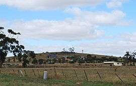
The town consists of mainly privately owned open land. It is named after the 200m high mountain it encompasses, called Mount Cottrell. Mount Cottrell is a volcanic cone formed by the radial eruption of numerous lava tongues, the most massive of the Werribee Plains volcanoes. The mountain was purchased by Melton Council in 2007 to preserve the significant geological and flora and fauna values on the site.
Mount Cottrell Post Office opened on 1 January 1866, closed in 1895, reopened in 1902 and closed again in 1958.[2]
External links
- "E2 Mount Cottrell - Eruption Point". Victorian Sources Online. Retrieved 5 June 2016.
References
- ↑ Australian Bureau of Statistics (27 June 2017). "Mount Cottrell (State Suburb)". 2016 Census QuickStats. Retrieved 8 July 2017.

- ↑ Premier Postal History, Post Office List, retrieved 2008-04-11