Cobblebank
| Cobblebank Victoria | |||||||||||||||
|---|---|---|---|---|---|---|---|---|---|---|---|---|---|---|---|
 Western BACE, Cobblebank | |||||||||||||||
 Cobblebank | |||||||||||||||
| Coordinates | 37°42′41″S 144°36′3″E / 37.71139°S 144.60083°ECoordinates: 37°42′41″S 144°36′3″E / 37.71139°S 144.60083°E | ||||||||||||||
| Established | 2017 | ||||||||||||||
| Postcode(s) | 3338 | ||||||||||||||
| LGA(s) | City of Melton | ||||||||||||||
| State electorate(s) | Melton | ||||||||||||||
| Federal Division(s) | Gorton | ||||||||||||||
| |||||||||||||||
Cobblebank is a developing suburb in the outer west of Melbourne, Victoria, Australia. Its local government area is the City of Melton. The suburb was gazetted by the Office of Geographic Names on 9 February 2017,[1] following a proposal for eleven new suburbs by the City of Melton. The new name officially came into effect in mid-2017.[2][3] Prior to the suburb's creation, the area was part of Melton South.
Cobblebank is bounded to the west by the Toolern Creek, which was gazetted in 1881 as a 'Permanent Reserve for Public Purposes'. The reserve includes the bed of the creek and is nominally 20.12 metres (one chain) wide from the banks of the creek,[4] Aboriginal artefacts have also been found in this area. The northern boundary is formed by the Western Freeway which connects Cobblebank to both Melbourne and Melton (and Ballarat beyond). The northern part of Cobblebank is home to Tabcorp Park, a horse racing venue used for harness racing.
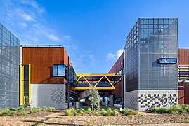
At Ferris Road, which runs through the centre of Cobblebank, is the recently completed 'Western Business Accelerator and Centre for Excellence' (Western BACE)[5] a community activity, and business development hub for Melbourne’s west. The centre offers commercial space for lease, and provides business coaching, and vocational education. Western BACE was built using sustainable principles in 2015[6] by the City of Melton with $14.62 million funding from the Australian Federal Government. It forms the first part of the proposed Toolern Town Centre.
The Toolern Town Centre[7] is a future major regional centre for a projected local population of up to 60,000 people in Melbourne's rapidly-growing western urban area.[8] Its development will occur over a number of decades, initially evolving from a local suburban hub in its first decade, to a regional business, retail, civic, education, medical, residential, entertainment and recreation centre when complete.[9] Toolern Railway Station[10] has been planned by the State Government of Victoria,[11] to be built near the junction of the Melbourne – Ballarat Railway and Ferris Road, after electrification works to Melton[12] are complete.
Cobblebank is bounded to the east by Mount Cottrell Road and to the south by a 100 hectare Toolern Regional Park, (adjacent to Bridge Road). The regional park is generally to the east of Toolern Creek and straddles both Cobblebank and the neighbouring suburb of Strathtulloh. As at April 2017 the Regional Park is still being developed and presently features an athletics track, sports field, and the Bridge Road Community Centre.
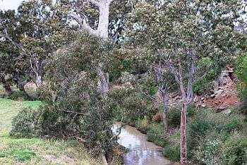 Toolern Creek, Cobblebank
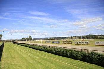 Tabcorp Park Raceway, Cobblebank
References
- ↑ "Locality boundaries". Department of Environment, Land, Water and Planning. State Government of Victoria. Retrieved 25 February 2017.
- ↑ Landy, Samantha (10 February 2017). "Eleven new suburbs to be established in the Melton growth area, west of Melbourne's CBD". Herald Sun. Archived from the original on 25 February 2017. Retrieved 25 February 2017.
- ↑ "New suburbs". City of Melton. Retrieved 25 February 2017.
- ↑ Crown Lands and Survey Victoria, Department of. "Parish of Kororoit, County of Bourke Map, 2 May 1978". digital.slv.vic.gov.au. Retrieved 2017-04-01.
- ↑ "Western Business Accelerator & Centre for Excellence". Retrieved 2017-04-01.
- ↑ "Western Business Accelerator and Centre for Excellence by Six Degrees wins 2015 Sustainability Awards – Large Commercial prize | Architecture And Design". Architecture And Design. Retrieved 2017-04-01.
- ↑ Government of Victoria, State (2017). "Metropolitan and major activity centres" (PDF).
- ↑ REMPLAN. "Melton Economic Profile – City of Melton". Melton Economic Profile – City of Melton. Retrieved 2017-04-01.
- ↑ "Toolern Urban Design Framework". Retrieved 2017-04-01.
- ↑ "Possible Toolern Railway Station". Railpage. Retrieved 2017-04-01.
- ↑ Government of Victoria, State (2017). "Improvements to transport infrastructure" (PDF).
- ↑ Carey, Adam (2016-02-24). "Long-planned Melton rail line upgrade being pushed for next state budget". The Age. Retrieved 2017-04-01.
External links
![]()