Mount Arethusa
| Mount Arethusa | |
|---|---|
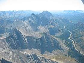 Mt. Arethusa and Little Arethusa from the north (Sept. 2006) | |
| Highest point | |
| Elevation | 2,912 m (9,554 ft) [1] |
| Prominence | 138 m (453 ft) [2] |
| Listing | Mountains of Alberta |
| Coordinates | 50°36′22″N 114°58′14″W / 50.60611°N 114.97056°WCoordinates: 50°36′22″N 114°58′14″W / 50.60611°N 114.97056°W [1] |
| Geography | |
 Mount Arethusa Location in Alberta | |
| Location | Alberta, Canada |
| Parent range | Misty Range |
| Topo map | NTS 82J/10 |
| Climbing | |
| Easiest route | Difficult scramble |
Mount Arethusa is a mountain located in the Canadian Rockies of Alberta, Canada.
It is located alongside Highway 40, immediately east of the Highwood Pass parking lot in Kananaskis Country, and is a part of the Misty Range of the Southern Continental Ranges. It is named after HMS Arethusa, a British cruiser sunk in the 1915 Battle of Dogger Bank.[3][4]
Mt. Arethusa and Little Arethusa form the southern wall of the Ptarmigan cirque which is a popular short hike from the Highwood Pass parking lot.
References
- 1 2 "Mount Arethusa". PeakFinder.com. Retrieved Oct 7, 2007.
- ↑ "Mount Arethusa". Bivouac.com. Retrieved Mar 30, 2013.
- ↑ Boles, Glen W.; Laurilla, Roger W.; Putnam, William L. (2006). Canadian Mountain Place Names. Vancouver: Rocky Mountain Books. p. 30. ISBN 978-1-894765-79-4.
- ↑ Place-names of Alberta. Ottawa: Geographic Board of Canada. 1928. p. 12.
This article is issued from
Wikipedia.
The text is licensed under Creative Commons - Attribution - Sharealike.
Additional terms may apply for the media files.