Motorways in the Republic of Macedonia

The motorways in the Republic of Macedonia are called avtopat (Macedonian: автопат) and the name, like its translation in most languages, simply means auto road.
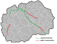
The system has inherited much from the former Yugoslavia. Pay-tolls (patarini) remain in place and the speed limit is 130 km/h (81 mph).[1] The total length of the motorway network is 242 km,[2] with extra 132 km being under construction.[3] Works are being done on three different stretches of A1, A2 and A3. After the completion in 2019, Macedonia will have a very good motorway network, comparable to those of the EU countries.[4]
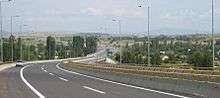
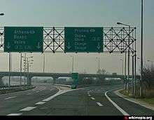
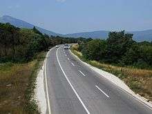
The highways were originally marked with yellow-colour hard shoulder lines and some of these remain in place, they are however slowly being phased out and replaced with white. The motorway roadsigns maintain their green colour background, a feature shared with Switzerland, Italy, Denmark, Sweden, Greece, Czech Republic, Lithuania and the United States as well as the other former Yugoslav republics. The roads are on the whole straight with good surfacing, and better maintained than the national roads.
Motorway A1
The first motorway runs from the Tabanovce border crossing with Serbia (for Preševo), passing Kumanovo (A2 junction), Petrovec (Skopje Airport) near Skopje (A3 junction), Veles, Gradsko (A5 junction) Negotino (A7 junction), and continuing onto the main border crossing with Greece, Bogorodica-Evzoni near Gevgelija.
The large part of this express route was built whilst Macedonia was a part of the SFR Yugoslavia, with the Kumanovo-Petrovec section first opened for traffic in 1979. The motorway was completed in 2004 in time for the Athens Olympics.
For approximately 30 km between Skopje Airport and Veles, the motorway splits, creating a gradual distance of several kilometres. The northbound route is the postulated motorway route whilst the slightly longer southbound route, with dangerous bends, is the old road and is being used as a freeway as it is only one-way. There are no plans at present to develop the northbound route into two separate carriageways thus perfecting the network.
The motorway A1 is part of European route E75.
Motorway A2
The A2 is a route that will connect Kriva Palanka and the Deve Bair border crossing with Bulgaria with Ohrid. The route passes Skopje through the ring-road and enters the already constructed motorway that connects Tetovo with Gostivar. The part of the route that bypasses Kičevo and ends in Ohrid is planned to be turned into a motorway with 4 lanes by 2018. Currently only the section from Miladinovci (interchange with A1) to Gostivar is a divided motorway, where the Tetovo-Gostivar section (25 km) is missing hard shoulders.
Motorway A3

The A3 will traverse the country from east to west, between the border with Bulgaria near Delčevo, via Kočani, Štip (A4 junction), Veles (A1 junction), Prilep, Bitola, ending in Ohrid (A2 junction). Construction of a new 47 km long motorway is under way and it will connect Skopje with Štip. Completion scheduled for 11.2018.
Future Motorway A4
The A4 is the connection of Skopje to Kosovo, part of European route E65. There are plans to turn this section into a motorway in near future, but no works are started yet.
The next segment of A4 will connect Štip (A3 junction) via Radoviš and Strumica to the border with Bulgaria near Novo Selo. [5] [6]
References
- ↑ Ministry of Internal Affairs Law for Public Transport p.29 (Mk) "Archived copy" (PDF). Archived from the original (PDF) on 2013-01-23. Retrieved 2013-02-16.
- ↑ http://www.roads.org.mk/255/road-network
- ↑ http://www.independent.mk/articles/16138/Most+Modern+Highway+Will+Take+Travelers+to+Ohrid
- ↑ http://www.independent.mk/articles/32293/Macedonia+Prime+Minister+Dimitriev+Expects+Skopje-Stip+Highway+to+Be+Fully+Built+in+
- ↑ http://wiki.openstreetmap.org/wiki/Macedonia/Road_network?setlang=en
- ↑ http://www.mtc.gov.mk/new_site/images/storija_doc/115/1908/13-2010.pdf