Morlupo
| Morlupo | ||
|---|---|---|
| Comune | ||
| Comune di Morlupo | ||
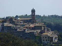 Morlupo view from West (April 2007) | ||
| ||
 Morlupo Location of Morlupo in Italy | ||
| Coordinates: 42°9′N 12°30′E / 42.150°N 12.500°ECoordinates: 42°9′N 12°30′E / 42.150°N 12.500°E | ||
| Country | Italy | |
| Region | Latium | |
| Metropolitan city | Rome (RM) | |
| Government | ||
| • Mayor | Ettore Iacomussi | |
| Area | ||
| • Total | 24.08 km2 (9.30 sq mi) | |
| Elevation | 207 m (679 ft) | |
| Population (30 November 2017)[1] | ||
| • Total | 8,679 | |
| • Density | 360/km2 (930/sq mi) | |
| Demonym(s) | Morlupesi | |
| Time zone | UTC+1 (CET) | |
| • Summer (DST) | UTC+2 (CEST) | |
| Postal code | 00067 | |
| Dialing code | 06 | |
| Patron saint | St. Mary the Assumpted | |
| Saint day | August 15 | |
| Website | Official website | |

Morlupo (Romanesco: Morlopu) is a comune (municipality) in the Metropolitan City of Rome in the Italian region Latium, located about 30 kilometres (19 mi) north of Rome.
Morlupo borders the following municipalities: Capena, Castelnuovo di Porto, Magliano Romano, Rignano Flaminio.
References
External links

This article is issued from
Wikipedia.
The text is licensed under Creative Commons - Attribution - Sharealike.
Additional terms may apply for the media files.