Canale Monterano
| Canale Monterano | ||
|---|---|---|
| Comune | ||
| Comune di Canale Monterano | ||
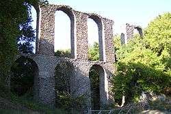 Roman aqueduct in Monterano. | ||
| ||
 Canale Monterano Location of Canale Monterano in Italy | ||
| Coordinates: 42°8′N 12°6′E / 42.133°N 12.100°E | ||
| Country | Italy | |
| Region | Latium | |
| Metropolitan city | Rome (RM) | |
| Frazioni | La Piana, Montevirginio | |
| Government | ||
| • Mayor | Alessandro Bettarelli | |
| Area | ||
| • Total | 36.92 km2 (14.25 sq mi) | |
| Elevation | 378 m (1,240 ft) | |
| Population (30 April 2017)[1] | ||
| • Total | 4,132 | |
| • Density | 110/km2 (290/sq mi) | |
| Demonym(s) | Canalesi | |
| Time zone | UTC+1 (CET) | |
| • Summer (DST) | UTC+2 (CEST) | |
| Postal code | 00060 | |
| Dialing code | 06 | |
| Patron saint | St. Bartholomew | |
| Saint day | August 24 | |
| Website | Official website | |

Canale Monterano is a comune (municipality), former bishopric and Latin titular see in the Metropolitan City of Rome, in the central Italian region of Lazio (Ancient Latium).
Canale Monterano, located about 40 kilometres (25 mi) northwest of Rome, borders the following municipalities : Blera, Manziana, Oriolo Romano, Tolfa and Vejano.
Main sights
- Giardini Botanici di Stigliano
- Ruins of the former village of Monterano (seat of a bishopric, see below) which was set on fire, together with its population, by the French army at the end of the 18th century
- Remains of Roman aqueduct
References
External links

| Authority control |
|---|
This article is issued from
Wikipedia.
The text is licensed under Creative Commons - Attribution - Sharealike.
Additional terms may apply for the media files.