Monte Compatri
| Monte Compatri | ||
|---|---|---|
| Comune | ||
| Comune di Monte Compatri | ||
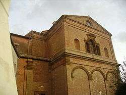 Apse of the Assunta Baroque parish church. | ||
| ||
 Monte Compatri Location of Monte Compatri in Italy | ||
| Coordinates: 41°48′29″N 12°44′14″E / 41.80806°N 12.73722°ECoordinates: 41°48′29″N 12°44′14″E / 41.80806°N 12.73722°E | ||
| Country | Italy | |
| Region | Latium | |
| Metropolitan city | Rome (RM) | |
| Frazioni | La Cucca, Laghetto, Molara, Pantano, Pratarena | |
| Government | ||
| • Mayor | Fabio D'Acuti | |
| Area | ||
| • Total | 24.57 km2 (9.49 sq mi) | |
| Elevation | 576 m (1,890 ft) | |
| Population (30 October 2017)[1] | ||
| • Total | 12,144 | |
| • Density | 490/km2 (1,300/sq mi) | |
| Demonym(s) | Monticiani | |
| Time zone | UTC+1 (CET) | |
| • Summer (DST) | UTC+2 (CEST) | |
| Postal code | 00040 | |
| Dialing code | 06 | |
| Saint day | 19 March | |
| Website | Official website | |

Monte Compatri is a comune (municipality) in the Metropolitan City of Rome in the Italian region Latium, located about 20 kilometres (12 mi) southeast of Rome on the Alban Hills. It is one of the Castelli Romani.
History
Monte Compatri has been identified with the ancient Labicum, a colony of Alba Longa. In the Middle Ages it was a fief of the Counts of Tusculum, then of the Annibaldi, the Altemps and the Borghese.
Main sights
- Parish church of Santa Maria Assunta in Cielo (1630–33), erected by will of Scipione Borghese. The campanile is the former communal tower. The façade was designed by Carlo Rainaldi
- Palazzo Borghese, the current town hall
- Gabii
- San Silvestro monastery
People
- Marco Mastrofini (1763–1845), philosopher and mathematician
- Cardinal Pompeo Colonna (1479–1530)
- Alessandro Moreschi (1858–1922) last castrato singer in the Sistine Chapel
Twin cities
References
External links

This article is issued from
Wikipedia.
The text is licensed under Creative Commons - Attribution - Sharealike.
Additional terms may apply for the media files.