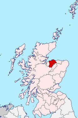
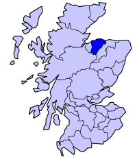
County of Moray
Coordinates: 57°18′N 3°18′W / 57.3°N 3.3°W
| Moray | |
|---|---|
| Historic county | |
 | |
| Country | Scotland |
| County town | Elgin |
| Area | |
| • Total | 476 sq mi (1,233 km2) |
| Ranked 17th of 34 | |
| Chapman code | MOR |
Moray (/ˈmʌri/; Scottish Gaelic: Moireibh [ˈmɤɾʲəv]), or Elginshire, is one of the registration counties of Scotland, bordering Nairnshire to the west, Inverness-shire to the south, and Banffshire to the east.[1][2] It was a local government county, with Elgin the county town, until 1975. Before 1889 there were two large exclaves of Moray situated within Inverness-shire, and an exclave of Inverness-shire situated within Moray. The Local Government (Scotland) Act 1889 transferred these exclaves to the counties which surrounded them. The county was officially called Elginshire, sharing the name of the Elginshire parliamentary constituency, so named since 1708.[3] The area became known as Moray after 1930 in official documents, but the term "Morayshire" was introduced in handwritten ledgers as there were problems in distinguishing Moray from Norway and Morar.[4][5]
In 1975, under the Local Government (Scotland) Act 1973, most of the county was combined with the Aberlour, Buckie, Cullen, Dufftown, Findochty, Keith and Portknockie areas of the county of Banffshire to form the Moray district of the Grampian region. The Grantown-on-Spey and Cromdale areas were combined with the Kingussie and Badenoch areas of the county of Inverness-shire to form the Badenoch and Strathspey district of the Highland region. In 1996 the Moray district was superseded by the council area of Moray 1996, under the provisions of the Local Government etc. (Scotland) Act 1994.
The registration county, for property, is 'County of Moray', and a slightly smaller area, also based on the former county, is a lieutenancy area named 'Moray'.
Coat of arms
Granted in 1927 by the Lord Lyon, Moray's coat-of-arms was: Quarterly: 1st and 4th Azure, three mullets argent; 2nd and 3rd Argent, three cushions gules within a tressure flory-counter-flory of the last. The motto was SUB SPE, Latin for "In Hope", a pun on the River Spey, which flows through the county. The coat of arms, described by Thomas Innes of Learney, a future Lord Lyon, in the Elgin Courant of 6 May 1927 as "the most beautiful county arms in Scotland", represented the clan Murray and Randolph, Earl of Moray, the two main landowners.[6]
Geography
There are a number of mountainous features within Moray, including Bin Hill near Cullen. Bin Hill is visible from a number of distant points including Longman Hill, situated to the east in coastal Aberdeenshire.[7]
| Administrative Morayshire 1889-1975 | |
|---|---|
 |
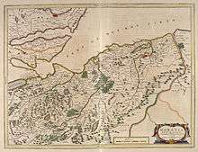
Towns and villages of the county
Civil parishes
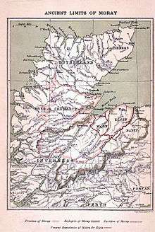
_%26_NAIRNSHIRE.jpg)
Civil parishes are still used for some statistical purposes, and separate census figures are published for them. As their areas have been largely unchanged since the 19th century this allows for comparison of population figures over an extended period of time.[8] From 1845 to 1930, parishes formed part of the local government system of Scotland, having parochial boards from 1845 to 1894.
In 1861 there were 15 civil parishes entirely in Moray:[9]
- Alves
- Birnie
- Dallas
- Drainie[10]
- Duffus
- Edinkillie (see List of listed buildings in Edinkillie, Moray)
- Elgin
- Forres
- Kinloss
- Knockando
- Lhanbryde
- Rafford
- Speymouth
- Spynie
- Urquhart
In 1861 Morayshire shared various civil parishes with three surrounding counties. Five with Banffshire:
three with Inverness-shire:
- Abernethy
- Cromdale
- Duthill
and one with Nairnshire:
See also
References
- ↑ Registers of Scotland. Publications, leaflets, Land Register Counties Archived 2 February 2010 at the Wayback Machine.
- ↑ http://www.scotlandsfamily.com/parish-map-aberdeen.htm
- ↑ L.Shaw, 1882
- ↑ http://www.moray.gov.uk/moray_standard/page_1537.html
- ↑ "Archived copy". Archived from the original on 16 December 2014. Retrieved 27 October 2014.
- ↑ Urquhart, R.M. Scottish Burgh and County Heraldry (1973 ed.). Heraldry Today. pp. 77–78. consulted 20 December 2013.
- ↑ C.M. Hogan, 2008
- ↑
- ↑
- ↑
- ↑ Scottish Places.
Further reading
- Lachlan Shaw and James Frederick Skinner Gordon (1882) The History of the Province of Moray: Comprising the Counties of Elgin and Nairn, the Greater Part of the County of Inverness and a Portion of the County of Banff, Published by Hamilton, Adams & co.,
- C.Michael Hogan The Modern Antiquarian (2008) Longman Hill.
- R.M. Urquhart (1973) Scottish Burgh and County Heraldry, published by Heraldry Today.
| Wikimedia Commons has media related to County of Moray. |