Moravian Thaya
| Moravian Thaya | |
|---|---|
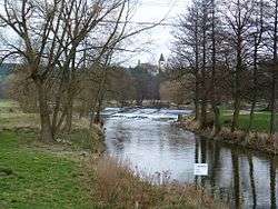 Moravian Thaya in Písečné | |
| Country | Czech Republic, Austria |
| Physical characteristics | |
| Main source |
near Třešť, Jihlava District, Vysočina Region 635 m (2,083 ft) |
| River mouth |
Raabs an der Thaya, Lower Austria 410 m (1,350 ft) 48°50′52″N 15°29′25″E / 48.84778°N 15.49028°ECoordinates: 48°50′52″N 15°29′25″E / 48.84778°N 15.49028°E |
| Length | 73.0 km (45.4 mi) [1] |
| Basin features | |
| Progression | Thaya→ Morava→ Danube→ Black Sea |
| Basin size | 630 km2 (240 sq mi) |
The Moravian Thaya (German: Mährische Thaya, Czech: Moravská Dyje) is a river in the Czech Republic and in Austria, and a 73 kilometres (45 mi) left tributary of the Thaya.
The Moravian Thaya originates about 4 kilometres (2.5 mi) southeast of Třešť near the village of Stajiště. From there it flows southward through or near the communities of Bezděkov, Panenská Rozsíčka, Urbanov, Žatec, Dyjice, Radkov, Slaviboř, and Černíč in the Vysočina Region. Further south it passes the South Bohemian settlements of Velký Pěčín, Dačice, Toužín, Hradišťko, Vnorovice, Staré Hobzí, Janov, Nové Hobzí, Modletice, Nové Sady, and Písečné before crossing the border into Austria.
In Austria, it joins the German Thaya at the city of Raabs an der Thaya. From there, the unified Thaya river flows generally eastward and re-enters the Czech Republic.
References
- ↑ Niederösterreich Atlas (Lower Austria)
External links
| Wikimedia Commons has media related to Moravská Dyje. |
- (in Czech) Moravská Dyje hydrological data