Mooroolbark railway station
Mooroolbark | |||||||||||
|---|---|---|---|---|---|---|---|---|---|---|---|
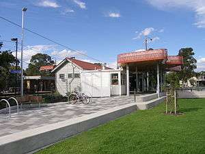 Mooroolbark station entrance following 2014 upgrade | |||||||||||
| Location | Brice Avenue, Mooroolbark | ||||||||||
| Coordinates | 37°47′05″S 145°18′45″E / 37.7847°S 145.3125°ECoordinates: 37°47′05″S 145°18′45″E / 37.7847°S 145.3125°E | ||||||||||
| Owned by | VicTrack | ||||||||||
| Operated by | Metro | ||||||||||
| Line(s) | Lilydale | ||||||||||
| Distance | 34.38 kilometres from Southern Cross | ||||||||||
| Platforms | 2 side | ||||||||||
| Tracks | 2 | ||||||||||
| Connections | Bus | ||||||||||
| Construction | |||||||||||
| Structure type | Ground | ||||||||||
| Parking | 364 | ||||||||||
| Bicycle facilities | 8 | ||||||||||
| Other information | |||||||||||
| Status | Premium station | ||||||||||
| Station code | MLK | ||||||||||
| Fare zone | Myki zone 2 | ||||||||||
| Website | Public Transport Victoria | ||||||||||
| History | |||||||||||
| Opened | 10 October 1887 | ||||||||||
| Electrified | Yes | ||||||||||
| Services | |||||||||||
| |||||||||||
Mooroolbark railway station is located on the Lilydale line in Victoria, Australia. It serves the eastern Melbourne suburb of Mooroolbark, opening on 10 October 1887.[1]
A crossover is located at the Up end of the station, which allows services to terminate here. The station also marks the end of double track on the Lilydale line.
The present day Platform 2 was provided in 1985, along with new track, to allow Down trains to enter the platform.[2][3][4] This was in conjunction with the provision of Automatic Signalling between Mooroolbark and Lilydale.[4]
In October 2013, three new small shelters were built at the ends of both platforms. Platform 1 has shelters at each end, while Platform 2 has one at the Down (Lilydale) end. Both platforms also had raised platforms installed, reducing the need for a wheelchair ramp to be used.
In 2015, the Level Crossing Removal Authority announced the removal of the Manchester Road level crossing. Preliminary planning has begun, though a construction date is yet to be announced.[5]
Platforms & services
Mooroolbark has two side platforms. It is serviced by Metro Trains' Lilydale line services.[6]
Platforms 1:
- Lilydale line: all stations and limited stops services to Flinders Street, Ringwood and Lilydale
Platforms 2:
- Lilydale line: services to Lilydale
Transport links
Ventura Bus Lines operates five routes to and from Mooroolbark station:
- 675: to Chirnside Park Shopping Centre[7]
- 680: to Lilydale station [8]
- Telebus Area 2: to Chirnside Park[9]
- Telebus Area 3: to Chirnside Park[10]
- Telebus Area 4: to Croydon station[11]
References
- ↑ Mooroolbark Vicsig
- ↑ "Ringwood East to Lilydale". Victorian Railways Signalling Diagram No 14’82. www.signaldiagramsandphotos.com. Retrieved 2016-05-13.
- ↑ "Ringwood East to Lilydale". The Met Signalling Diagram No 57’85. www.signaldiagramsandphotos.com. Retrieved 2016-05-13.
- 1 2 Works. Australian Railway Historical Society (Victorian Division). November 1985. p. 344. ISSN 0310-7477.
- ↑ "Projects in planning". levelcrossings.vic.gov.au. Archived from the original on 13 January 2016. Retrieved 19 January 2016.
- ↑ Lilydale Line timetable Public Transport Victoria
- ↑ Route 675 Chirnside Park - Mooroolbark timetable Public Transport Victoria
- ↑ Route 680 Lilydale - Mooroolbark timetable Public Transport Victoria
- ↑ Telebus 2 Mooroolbark station - Chinside Park timetable Public Transport Victoria
- ↑ Telebus 3 Mooroolbark station - Chinside Park timetable Public Transport Victoria
- ↑ Telebus 4 Mooroolbark station - Chinside Park timetable Public Transport Victoria
External links
- Melway map at street-directory.com.au