Moores Bridge, Alabama
| Moores Bridge, Alabama | |
|---|---|
| Unincorporated community | |
 Moores Bridge, Alabama  Moores Bridge, Alabama | |
| Coordinates: 33°26′55″N 87°47′37″W / 33.44861°N 87.79361°WCoordinates: 33°26′55″N 87°47′37″W / 33.44861°N 87.79361°W | |
| Country | United States |
| State | Alabama |
| County | Tuscaloosa |
| Elevation | 285 ft (87 m) |
| Time zone | UTC-6 (Central (CST)) |
| • Summer (DST) | UTC-5 (CDT) |
| Area code(s) | 205 |
| GNIS feature ID | 158874[1] |
Moores Bridge, also spelled Moors Bridge, is an unincorporated community in Tuscaloosa County, Alabama, United States. Moores Bridge is located along Alabama State Route 171, 24 miles (39 km) north-northwest of Tuscaloosa.
History
Moores Bridge is named for the bridge built by Duncan Taney Moore over the Sipsey River.[2] A post office operated under the name Moores Bridge from 1853 to 1966.[3]
Notable person
- James Jefferson Mayfield, Associate Justice of the Alabama Supreme Court from 1908 to 1920[4]
References
- ↑ "Moores Bridge". Geographic Names Information System. United States Geological Survey.
- ↑ Foscue, Virginia (1989). Place Names in Alabama. Tuscaloosa: The University of Alabama Press. p. 96. ISBN 0-8173-0410-X.
- ↑ "Tuscaloosa County". Jim Forte Postal History. Retrieved 27 March 2015.
- ↑ Alabama. Department of Archives and History (1915). Alabama Official and Statistical Register. Brown Printing Company. p. 49.
Municipalities and communities of Tuscaloosa County, Alabama, United States | ||
|---|---|---|
| Cities | 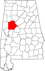 | |
| Towns | ||
| CDP | ||
| Unincorporated communities | ||
| Ghost town | ||
| Footnotes | ‡This populated place also has portions in an adjacent county or counties | |
This article is issued from
Wikipedia.
The text is licensed under Creative Commons - Attribution - Sharealike.
Additional terms may apply for the media files.