Duncanville, Alabama
| Duncanville, Alabama | |
|---|---|
| Unincorporated community | |
 Duncanville, Alabama  Duncanville, Alabama | |
| Coordinates: 33°03′42″N 87°26′32″W / 33.06167°N 87.44222°WCoordinates: 33°03′42″N 87°26′32″W / 33.06167°N 87.44222°W | |
| Country | United States |
| State | Alabama |
| County | Tuscaloosa |
| Elevation | 243 ft (74 m) |
| Time zone | UTC-6 (Central (CST)) |
| • Summer (DST) | UTC-5 (CDT) |
| ZIP code | 35456 |
| Area code(s) | 205 |
| GNIS feature ID | 159538[1] |
Duncanville is an unincorporated community in Tuscaloosa County, Alabama, United States. Duncanville is located along U.S. Route 82, 12.5 miles (20.1 km) southeast of Tuscaloosa. Duncanville has a post office with ZIP code 35456, which opened on August 22, 1898.[2][3] Duncanville was named in honor of either William M. Duncan, a local property owner, or W. Butler Duncan, an official with the Gulf, Mobile, and Northern Railroad.[4]
References
- ↑ "Duncanville". Geographic Names Information System. United States Geological Survey.
- ↑ United States Postal Service (2012). "USPS - Look Up a ZIP Code". Retrieved 2012-02-15.
- ↑ "Postmaster Finder - Post Offices by ZIP Code". United States Postal Service. Retrieved June 4, 2013.
- ↑ Foscue, Virginia (1989). Place Names in Alabama. Tuscaloosa: The University of Alabama Press. p. 50. ISBN 0-8173-0410-X.
Municipalities and communities of Tuscaloosa County, Alabama, United States | ||
|---|---|---|
| Cities | 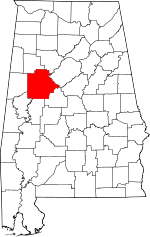 | |
| Towns | ||
| CDP | ||
| Unincorporated communities | ||
| Ghost town | ||
| Footnotes | ‡This populated place also has portions in an adjacent county or counties | |
This article is issued from
Wikipedia.
The text is licensed under Creative Commons - Attribution - Sharealike.
Additional terms may apply for the media files.