Moore Haven, Florida
| Moore Haven, Florida | |
|---|---|
| City | |
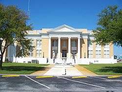 Glades County Courthouse | |
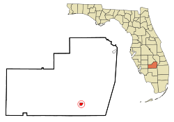 Location in Glades County and the state of Florida | |
| Coordinates: 26°50′N 81°6′W / 26.833°N 81.100°WCoordinates: 26°50′N 81°6′W / 26.833°N 81.100°W | |
| Country |
|
| State |
|
| County | Glades |
| Area[1] | |
| • Total | 1.15 sq mi (2.98 km2) |
| • Land | 1.08 sq mi (2.79 km2) |
| • Water | 0.07 sq mi (0.19 km2) |
| Elevation | 13 ft (4 m) |
| Population (2010) | |
| • Total | 1,680 |
| • Estimate (2016)[2] | 1,838 |
| • Density | 1,708.18/sq mi (659.37/km2) |
| Time zone | UTC-5 (Eastern (EST)) |
| • Summer (DST) | UTC-4 (EDT) |
| ZIP code | 33471 |
| Area code(s) | 863 |
| FIPS code | 12-46550[3] |
| GNIS feature ID | 0287104[4] |
| Website | http://www.moorehaven.org |
Moore Haven is a city in, and the county seat of, Glades County, Florida, United States. The population was 1,680 at the 2010 census.[5] Moore Haven is located on the southwest shoreline of Lake Okeechobee.
History
The community was named after James A. Moore, its founder. In its early days, Moore Haven was often called "Little Chicago", reflecting its status as a significant boom town. It was ideally located at the apex of Lake Okeechobee and the Caloosahatchee Canal.
In 1917, Marion Newhall Horwitz was elected as the first woman who served as mayor and the first woman mayor in Florida.[6]
The Great Miami Hurricane of 1926 dramatically altered the landscape of the area. The storm surge from the lake caused widespread death and destruction, sometimes literally relocating houses to the opposite side of the river. The town might have recovered, but it was hit not long after by the 1928 Okeechobee Hurricane. This decimated areas that had escaped damage in 1926.
Today Moore Haven is a small, sleepy town that has little industry and infrastructure. Moore Haven is home to the Annual Chalo Nitka Festival, which is held the first weekend in March.
A large bridge that crosses the Caloosahatchee River was completed in the last 10 years. There are two access points to the Lake Okeechobee Scenic Trail, which passes through the town and around Lake Okeechobee.
The Westergaard House, built in 1920, located on 270 Avenue L Southwest, is the headquarters of the Glades County Historical Society.[7]
Education
Geography
Moore Haven is located at 26°50′N 81°6′W (26.834,-81.096).[9]
According to the United States Census Bureau, the city has a total area of 1.1 square miles (2.8 km2), of which 1.1 square miles (2.8 km2) is land and 0.1 square miles (0.26 km2) (6.09%) is water.
Demographics
| Historical population | |||
|---|---|---|---|
| Census | Pop. | %± | |
| 1920 | 623 | — | |
| 1930 | 612 | −1.8% | |
| 1940 | 831 | 35.8% | |
| 1950 | 636 | −23.5% | |
| 1960 | 790 | 24.2% | |
| 1970 | 974 | 23.3% | |
| 1980 | 1,250 | 28.3% | |
| 1990 | 1,432 | 14.6% | |
| 2000 | 1,635 | 14.2% | |
| 2010 | 1,680 | 2.8% | |
| Est. 2016 | 1,838 | [2] | 9.4% |
| U.S. Decennial Census[10] | |||
As of the census[3] of 2000, there were 1,635 people, 572 households, and 414 families residing in the city. The population density was 1,508.8 people per square mile (584.5/km²). There were 792 housing units at an average density of 730.9 per square mile (283.1/km²). The racial makeup of the city was 61.28% White, 22.32% African American, 0.80% Native American, 0.43% Asian, 14.56% from other races, and 0.61% from two or more races. Hispanic or Latino of any race were 28.01% of the population.
There were 572 households out of which 35.0% had children under the age of 18 living with them, 48.8% were married couples living together, 14.5% had a female householder with no husband present, and 27.6% were non-families. 22.0% of all households were made up of individuals and 10.1% had someone living alone who was 65 years of age or older. The average household size was 2.81 and the average family size was 3.23.
In the city, the population was spread out with 31.8% under the age of 18, 8.1% from 18 to 24, 25.5% from 25 to 44, 19.8% from 45 to 64, and 14.8% who were 65 years of age or older. The median age was 33 years. For every 100 females, there were 107.8 males. For every 100 females age 18 and over, there were 109.2 males.
The median income for a household in the city was $26,801, and the median income for a family was $28,542. Males had a median income of $26,615 versus $20,250 for females. The per capita income for the city was $12,183. About 19.0% of families and 23.8% of the population were below the poverty line, including 30.0% of those under age 18 and 16.8% of those age 65 or over.
In popular culture
- Moore Haven is mentioned in the Sundance drama, Camp X-Ray (film), as the hometown of PFC Amy Cole.
References
- ↑ "2016 U.S. Gazetteer Files". United States Census Bureau. Retrieved Jul 7, 2017.
- 1 2 "Population and Housing Unit Estimates". Retrieved June 9, 2017.
- 1 2 "American FactFinder". United States Census Bureau. Retrieved 2008-01-31.
- ↑ "US Board on Geographic Names". United States Geological Survey. 2007-10-25. Retrieved 2008-01-31.
- ↑ "Find a County". National Association of Counties. Retrieved 2011-06-07.
- ↑ "Woman Mayor Quits Job; Time to Be Devoted to Farm, Since Husband Is in Army". Morning Oregonian. Portland, Oregon. June 22, 1918. p. 1. Retrieved January 4, 2018.
- ↑ "Glades County Historical Society". gladescountyhs.org. Retrieved 2018-10-13.
- 1 2 "Glades County School District". Glades County School District.
- ↑ "US Gazetteer files: 2010, 2000, and 1990". United States Census Bureau. 2011-02-12. Retrieved 2011-04-23.
- ↑ "Census of Population and Housing". Census.gov. Retrieved June 4, 2015.
External links
Municipalities and communities of Glades County, Florida, United States | ||
|---|---|---|
| City | 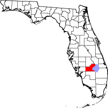 | |
| CDP | ||
| Indian reservation | ||
| Unincorporated communities | ||