Monywa
| Monywa မုံရွာမြို့ | |
|---|---|
| City | |
 Monywa | |
 Monywa Location in Burma | |
| Coordinates: 22°6′30″N 95°8′30″E / 22.10833°N 95.14167°ECoordinates: 22°6′30″N 95°8′30″E / 22.10833°N 95.14167°E | |
| Country |
|
| Region |
|
| District | Monywa District |
| Township | Monywa Township |
| Population (2014 Census)[1] | |
| • City | 372,095 |
| • Urban | 207,489 |
| • Rural | 164,606 |
| • Religions | Buddhism |
| Time zone | UTC+6.30 (MST) |
| Area code(s) | 71[2] |
Monywa (Burmese: မုံရွာမြို့; MLCTS: muṃ rwa mrui.; pronounced [mòʊɴjwà mjo̰]) is a city in Sagaing Region, Myanmar, located 136 km north-west of Mandalay on the eastern bank of the River Chindwin.
It is also known as Neem city because most of the streets of the city are covered by very old Neem trees. It is one of the Unique Cities of the World.
Climate
Monywa and neighbouring parts of the 'Dry Valley' are the only places in South East Asia where you find the Hot Semi-arid/steppe climate(BSh).[3] [4] The city barely misses the Tropical savanna/Wet and dry climate(Aw) classification due to the very high temperatures(high evaporation levels) and a long dry season. This has to do with the 'Dry valley' being located in the rain shadow of the Arakan Mountains. Temperatures are very high throughout the year, although the winter months (December–February) are significantly milder(around 21°C in January). The early monsoon months from April to July are especially hot, with average high temperatures reaching 38.4 °C (101.1 °F) in April.
Monywa received 139 millimetres (5.5 in) of rainfall on 19 Oct 2011. This was a new record for rainfall within 24 hours in October in Monywa for the last 47 years. The previous record was 135 millimetres (5.3 in) on 24 Oct 1967.[5]
| Climate data for Monywa | |||||||||||||
|---|---|---|---|---|---|---|---|---|---|---|---|---|---|
| Month | Jan | Feb | Mar | Apr | May | Jun | Jul | Aug | Sep | Oct | Nov | Dec | Year |
| Record high °C (°F) | 36.5 (97.7) |
40.6 (105.1) |
45.2 (113.4) |
45.8 (114.4) |
45.6 (114.1) |
43.3 (109.9) |
43.5 (110.3) |
43.3 (109.9) |
43.1 (109.6) |
41.2 (106.2) |
39.7 (103.5) |
36.1 (97) |
45.8 (114.4) |
| Average high °C (°F) | 27.9 (82.2) |
31.5 (88.7) |
35.3 (95.5) |
38.3 (100.9) |
37.3 (99.1) |
30.9 (87.6) |
34.4 (93.9) |
33.6 (92.5) |
33.3 (91.9) |
32.1 (89.8) |
29.8 (85.6) |
27.6 (81.7) |
32.7 (90.8) |
| Average low °C (°F) | 13.9 (57) |
11.1 (52) |
14.2 (57.6) |
19.1 (66.4) |
25.5 (77.9) |
25.7 (78.3) |
25.9 (78.6) |
25.6 (78.1) |
25.0 (77) |
23.4 (74.1) |
19.5 (67.1) |
21.2 (70.2) |
20.8 (69.5) |
| Record low °C (°F) | 3.3 (37.9) |
5.5 (41.9) |
6.6 (43.9) |
10.7 (51.3) |
15.8 (60.4) |
19.8 (67.6) |
21.3 (70.3) |
20.8 (69.4) |
19.4 (66.9) |
14.9 (58.8) |
8.5 (47.3) |
3.0 (37.4) |
3 (37.4) |
| Average precipitation mm (inches) | 2 (0.08) |
2 (0.08) |
2 (0.08) |
26 (1.02) |
101 (3.98) |
106 (4.17) |
71 (2.8) |
131 (5.16) |
162 (6.38) |
134 (5.28) |
42 (1.65) |
6 (0.24) |
785 (30.92) |
| Source: NOAA (1961-1990) [6] | |||||||||||||
Transport
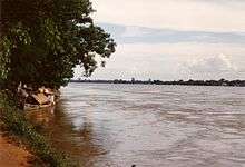
Monywa is served by the Mandalay-Budalin branch railway line, but is best reached by bus as the road from Mandalay is in reasonably good shape. Monywa is linked by road to Budalin, Dabayin, Ye-U and Kin-U, and by rail to Sagaing and the Mandalay - Myitkyina line.[7] River transport on the Chindwin has always been important as it is navigable for 640 km (400 mi) to Hkamti during the monsoon season, and most of the year to Homalin.[8][9]
Economy


Monywa is a major centre for trade and commerce and for agricultural produce from the surrounding Chindwin valley, especially beans, orange, pulses and jaggery (palm sugar). In addition, the local industry includes mills for the production of cotton, flour, noodles, and edible oils. Sausages from Alon called wet udaunk are quite popular, and Budalin longyi (sarong) is known for the strength of the fabric and its checked patterns. Monywa's rough cotton blankets are famous throughout Myanmar (with Monywa providing 80% of the country's blankets for a century),[10] and some can even be found sewn up into knapsacks sold to unsuspecting tourists in Bangkok. Other regional crafts include bamboo and reed products, bullock carts and agricultural implements. The village of Kyaukka is well known for its lacquerware utensils for everyday use.
Black market goods from India, especially saris and bicycle parts, pass through Monywa on their way to other parts of Myanmar.
Attractions
The major tourist attraction in Monywa is Thambuddhe Pagoda , a Buddhist temple with a huge stupa resembling Indonesia's Borobudur. It dates from 1303, although it was reconstructed in 1939. It is said to contain over 500,000 images of Buddha. Close by is the Maha Bodhi Tahtaung Laykyun Sekkya standing Buddha statue, the tallest statue in the world, with 115,82 metres (at a total of 129.23 metres, including pedestal). This is the focal point of a sprawling site filled with Buddha statues, bodhi trees, and pagodas, established by the Maha Bodhi Ta Htaung Sayadaw in the 1960s. It includes also a 95-metre long reclining Buddha statue.[11]
Another attraction is the Phowintaung cave complex across the Chindwin River, approximately 25 kilometres (16 mi) west of Monywa.
Nyaung-gan Bronze Age cemetery, dated to between 1,500 BCE and 500 BCE, in Budalin with bronze tools, ceramics and stone artifacts is 60 minutes travel on a narrow road north of Monywa.[12]
Very few tourists visit Monywa as its facilities are limited.
Education

The city is home to:
Health care
Public Hospitals
- Monywa General Hospital
- Monywa Women and Children Hospital
Politics
The insurgent Burmese Communist Party (BCP) was centred in the Monywa area (west of the Chindwin River) for many years. Although the BCP is no longer active, the Myanmar military presence in Monywa remains heavy.
Notable residents
- Thant Sin Maung
- Tun Kyi
- Kyaw Hsan
- U Lu Tin (1930-)
Gallery
 Giant reclining Buddha at Bodhi Tahtaung
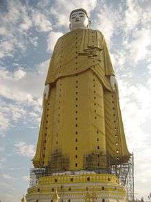 Giant standing Buddha (under construction in the first picture)
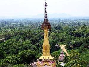
 Shwezigon-Paya
 Aung Setkya Paya
Notes
- ↑ The 2014 Myanmar Population and Housing Census The Union Report Census Report Volume 2. Department of Population, Ministry of Immigration and Population. May 2015. p. 52. Archived from the original on 2016-03-06. Retrieved 2018-09-06.
- ↑ "Myanmar Area Codes". Archived from the original on 2009-12-01. Retrieved 2009-04-10.
- ↑ http://www.meteotemplate.com/template/plugins/climateClassification/koppen.php
- ↑ https://en.climate-data.org/country/151/
- ↑ http://www.mrtv3.net.mm/newpaper/2110newsm.pdf%5Bpermanent+dead+link%5D Page 19 Col 2
- ↑ "Monywa Climate Normals 1961-1990". National Oceanic and Atmospheric Administration. Retrieved January 11, 2013.
- ↑ "Sr Gen Than Shwe urges officials to collectively strive for turning Sagaing Division into granary of Upper Myanmar Assistance assured to upgrade Monywa-Budalin-Dabayin-YeU-KhinU Road". The New Light of Myanmar, December 3, 2002. Archived from the original on 2009-02-28. Retrieved 2008-10-12.
- ↑ "Chindwin River". Encyclopædia Britannica online. Retrieved 2008-10-12.
- ↑ "CHINDWIN". Online Encyclopaedia. Retrieved 2008-10-12.
- ↑ Sandar Lwin (21 March 2011). "In Monywa, 'market economy' leaves some businesses behind". Myanmar Times. Archived from the original on 16 September 2011. Retrieved 23 August 2011.
- ↑ "Nev World Wonders".
- ↑ Once feted by Myanmar's junta, Bronze Age cemetery site returns to the spotlight, Forntier Myanmar.
- ↑ "Ministry of Science and Technology". MOST, February 2009. Archived from the original on 2009-02-25. Retrieved 2009-04-14.
- ↑ "Ministry of Science and Technology". MOST, February 2009. Archived from the original on 2011-07-19. Retrieved 2009-04-14.
External links
| Wikimedia Commons has media related to Monywa. |
- City of Monywa
- Burman photograph album 1897 Old photos of Monywa
- Chindwin River - lifeblood of upper Sagaing Myanmar Times, January 16–22, 2006