Sagaing
| Sagaing စစ်ကိုင်းမြို့ | |
|---|---|
| City | |
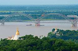 The Yadanabon Bridge on the Irrawaddy | |
 Sagaing Location in Burma | |
| Coordinates: 21°52′56″N 95°58′43″E / 21.88222°N 95.97861°ECoordinates: 21°52′56″N 95°58′43″E / 21.88222°N 95.97861°E | |
| Country |
|
| Division |
|
| Population (2011) | 69,917 |
| • Religions | Buddhism |
| Time zone | UTC+6.30 (MST) |
Sagaing (Burmese: စစ်ကိုင်းမြို့; MLCTS: cac kuing: mrui) is the capital of Sagaing Region (formerly Sagaing Division). Located on the Irrawaddy River, 20 km to the south-west of Mandalay on the opposite bank of the river, Sagaing, with numerous Buddhist monasteries is an important religious and monastic centre. The pagodas and monasteries crowd the numerous hills along the ridge running parallel to the river. The central pagoda, Soon U Ponya Shin Pagoda, is connected by a set of covered staircases that run up the 240 m hill.
Today, with about 70,000 inhabitants, the city is part of Mandalay built-up area with more than 1,022,000 inhabitants estimated in 2011. The city is a frequent tourist destination of day trippers. Within the city are the Sagaing Institute of Education, the Sagaing Education College, Sagaing University, Technological University (Sagaing), and co-operative university (Sagaing).
Name
The classical name of Sagaing is Zeyapura (ဇေယျာပူရ; Pali: Jayapura), which literally translates to "city of victory."[1]
History
Sagaing was the capital of Sagaing Kingdom (1315–1364), one of the minor kingdoms that rose up after the fall of Pagan dynasty, where one of Thihathu's sons, Athinkhaya, established himself.[2]:227 During the Ava period (1364–1555), the city was the common fief of the crown prince or senior princes. The city briefly became the royal capital between 1760 and 1763 in the reign of King Naungdawgyi.
On 8 August 1988, Sagaing was the site of demonstrations which were concluded by a massacre in which around 300 civilians were killed.[3]
People
- List of kings of Sagaing Kingdom
- Sithu Kyawhtin, King of Ava (1552–1555)
- Zhu Youlang, Prince of Gui, last Ming Dynasty claimant to China, lived in exile at Sagaing in 1661
- Maurice Collis, author of Trials in Burma, district commissioner of the Sagaing district in 1928
Places of interest

The Kaunghmudaw Pagoda (Burmese: ကောင်းမှုတော် ဘုရား [káʊɴ m̥ṵ dɔ́ pʰəjá]; Yaza Mani Sula Kaunghmudaw (ရာဇမဏိစူဠာ ကောင်းမှုတော်); Pali: Rājamaṇicūḷā) is a large pagoda on the northwestern outskirts of Sagaing.
Images
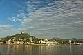 Sagaing Hill
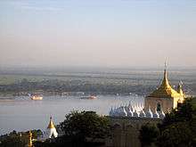 Irrawaddy River from Sagaing Hill, Sagaing
 Pagodas that dot Sagaing
 U Min Thonze Cave
 Sone Oo Pone Nya Shin Pagoda, Sagaing Hill
 Umin Thonze Pagoda
References
- ↑ Hardiman, John Percy (1901). Gazetteer of Upper Burma and the Shan States. Superintendent, Government Printing, Burma.
- ↑ Coedès, George (1968). Walter F. Vella, ed. The Indianized States of south-east Asia. trans.Susan Brown Cowing. University of Hawaii Press. ISBN 978-0-8248-0368-1.
- ↑ Irrawaddy article 1997 Archived 2010-10-04 at the Wayback Machine.
Sagaing | ||
| Preceded by Pinya |
Capital of Sagaing Kingdom June 1315 – April 1364 |
Succeeded by End of Kingdom |
| Preceded by New Kingdom |
Capital of Ava Kingdom April – September 1364 |
Succeeded by Pinya |
| Preceded by Shwebo |
Capital of Burma 26 July 1760 – 23 July 1765 |
Succeeded by Ava |
| Wikimedia Commons has media related to Sagaing. |
| Wikisource has the text of the 1911 Encyclopædia Britannica article Sagaing. |