Monument Square Historic District (Jamaica Plain, Boston, Massachusetts)
|
Monument Square Historic District | |
 | |
  | |
| Location | Roughly bounded by Jamaicaway, Pond, Centre and Eliot Sts., Jamaica Plain, Boston, Massachusetts |
|---|---|
| Coordinates | 42°18′33.9″N 71°6′56.8″W / 42.309417°N 71.115778°WCoordinates: 42°18′33.9″N 71°6′56.8″W / 42.309417°N 71.115778°W |
| Area | 43 acres (17 ha) |
| Architect | Multiple |
| Architectural style | Early Republic, Bungalow/Craftsman, Late Victorian |
| NRHP reference # | [1] |
| Added to NRHP | October 11, 1990 |
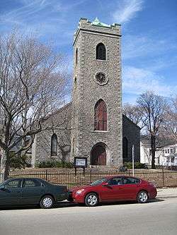
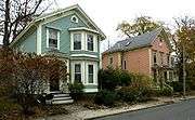
Monument Square Historic District is a predominantly residential historic district north of Monument Square in Jamaica Plain, a neighborhood of Boston, Massachusetts. The 43 acres (17 ha) district is bounded on the northwest by the Jamaicaway, the northeast by Myrtle and Pond Streets, the southeast by Centre Street (excluding the commercial properties on Centre Street itself), and Holbrook and Eliot Streets to the west. This area, originally developed as country estates, was developed as a residential area in the late 19th and early 20th centuries, with its architecture reflecting a diversity of styles. Prominent non-residential buildings including the First Church of Jamaica Plain, Eliot Hall, and the Eliot School. Also included in the district is Jamaica Plain's Gothic Soldier's Monument, at the junction of South and Centre Streets.[2]
The district was added to the National Register of Historic Places on October 11, 1990.[1]
Gallery


See also
References
- 1 2 National Park Service (2009-03-13). "National Register Information System". National Register of Historic Places. National Park Service.
- ↑ "NRHP nomination for Monument Square Historic District". Commonwealth of Massachusetts. Retrieved 2015-10-30.
| Topics |  | ||||||||||||||||
|---|---|---|---|---|---|---|---|---|---|---|---|---|---|---|---|---|---|
| Lists by county | |||||||||||||||||
| Lists by city |
| ||||||||||||||||
| Other lists | |||||||||||||||||
| |||||||||||||||||