Monticello d'Alba
| Monticello d'Alba | ||
|---|---|---|
| Comune | ||
| Comune di Monticello d'Alba | ||
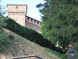 The castle of Monticello. | ||
| ||
 Monticello d'Alba Location of Monticello d'Alba in Italy | ||
| Coordinates: 44°43′N 7°57′E / 44.717°N 7.950°ECoordinates: 44°43′N 7°57′E / 44.717°N 7.950°E | ||
| Country | Italy | |
| Region | Piedmont | |
| Province | Cuneo (CN) | |
| Government | ||
| • Mayor | Monica Settimo | |
| Area | ||
| • Total | 10.1 km2 (3.9 sq mi) | |
| Elevation | 320 m (1,050 ft) | |
| Population (31 May 2007)[1] | ||
| • Total | 2,079 | |
| • Density | 210/km2 (530/sq mi) | |
| Demonym(s) | Monticellesi | |
| Time zone | UTC+1 (CET) | |
| • Summer (DST) | UTC+2 (CEST) | |
| Postal code | 12066 | |
| Dialing code | 0173 | |
| Website | Official website | |
Monticello d'Alba is a comune (municipality) in the Province of Cuneo in the Italian region Piedmont, located on the left bank of the Tanaro river, about 45 kilometres (28 mi) southeast of Turin and about 50 kilometres (31 mi) northeast of Cuneo.
It is home to one of the best preserved castles in Piedmont.
Twin towns — sister cities
Monticello d'Alba is twinned with:
References

This article is issued from
Wikipedia.
The text is licensed under Creative Commons - Attribution - Sharealike.
Additional terms may apply for the media files.