Montfaucon-d'Argonne
| Montfaucon-d'Argonne | |
|---|---|
| Commune | |
 Montfaucon-d'Argonne Location within Grand Est region  Montfaucon-d'Argonne | |
| Coordinates: 49°16′20″N 5°07′59″E / 49.2722°N 5.1331°ECoordinates: 49°16′20″N 5°07′59″E / 49.2722°N 5.1331°E | |
| Country | France |
| Region | Grand Est |
| Department | Meuse |
| Arrondissement | Verdun |
| Canton | Clermont-en-Argonne |
| Intercommunality | Montfaucon–Varennes en Argonne |
| Government | |
| • Mayor (2008–2014) | René Beausoleil |
| Area1 | 23.61 km2 (9.12 sq mi) |
| Population (1999)2 | 314 |
| • Density | 13/km2 (34/sq mi) |
| Time zone | UTC+1 (CET) |
| • Summer (DST) | UTC+2 (CEST) |
| INSEE/Postal code | 55346 /55270 |
| Elevation |
198–338 m (650–1,109 ft) (avg. 280 m or 920 ft) |
|
1 French Land Register data, which excludes lakes, ponds, glaciers > 1 km2 (0.386 sq mi or 247 acres) and river estuaries. 2 Population without double counting: residents of multiple communes (e.g., students and military personnel) only counted once. | |
Montfaucon-d'Argonne is a commune in the Meuse department in Grand Est in north-eastern France.
See also

American Monument.
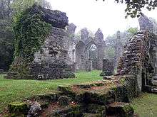
Ruined church at Montfaucon-d'Argonne. The blocky structure on the left is a German WWI observation post.
| Wikimedia Commons has media related to Montfaucon-d'Argonne. |
This article is issued from
Wikipedia.
The text is licensed under Creative Commons - Attribution - Sharealike.
Additional terms may apply for the media files.