Cunel
| Cunel | |
|---|---|
| Commune | |
 Cunel Location within Grand Est region  Cunel | |
| Coordinates: 49°20′12″N 5°07′02″E / 49.3367°N 5.1172°ECoordinates: 49°20′12″N 5°07′02″E / 49.3367°N 5.1172°E | |
| Country | France |
| Region | Grand Est |
| Department | Meuse |
| Arrondissement | Verdun |
| Canton | Clermont-en-Argonne |
| Intercommunality | Communauté de communes du Val Dunois |
| Government | |
| • Mayor (2008–2014) | Pierre Sibille |
| Area1 | 4.69 km2 (1.81 sq mi) |
| Population (1999)2 | 18 |
| • Density | 3.8/km2 (9.9/sq mi) |
| Time zone | UTC+1 (CET) |
| • Summer (DST) | UTC+2 (CEST) |
| INSEE/Postal code | 55140 /55110 |
| Elevation |
224–301 m (735–988 ft) (avg. 260 m or 850 ft) |
|
1 French Land Register data, which excludes lakes, ponds, glaciers > 1 km2 (0.386 sq mi or 247 acres) and river estuaries. 2 Population without double counting: residents of multiple communes (e.g., students and military personnel) only counted once. | |
Cunel is a commune in the Meuse department in Grand Est in north-eastern France.
See also
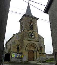
Church in the village of Cunel, France. The steeple was a German machine gun post during the Meuse-Argonne Offensive.
| Wikimedia Commons has media related to Cunel. |
This article is issued from
Wikipedia.
The text is licensed under Creative Commons - Attribution - Sharealike.
Additional terms may apply for the media files.