Dagonville
| Dagonville | |
|---|---|
| Commune | |
 Dagonville Location within Grand Est region  Dagonville | |
| Coordinates: 48°47′33″N 5°23′50″E / 48.7925°N 5.3972°ECoordinates: 48°47′33″N 5°23′50″E / 48.7925°N 5.3972°E | |
| Country | France |
| Region | Grand Est |
| Department | Meuse |
| Arrondissement | Commercy |
| Canton | Vaucouleurs |
| Government | |
| • Mayor (2008–2014) | Dominique Wentz |
| Area1 | 13.01 km2 (5.02 sq mi) |
| Population (1999)2 | 77 |
| • Density | 5.9/km2 (15/sq mi) |
| Time zone | UTC+1 (CET) |
| • Summer (DST) | UTC+2 (CEST) |
| INSEE/Postal code | 55141 /55500 |
| Elevation |
284–387 m (932–1,270 ft) (avg. 300 m or 980 ft) |
|
1 French Land Register data, which excludes lakes, ponds, glaciers > 1 km2 (0.386 sq mi or 247 acres) and river estuaries. 2 Population without double counting: residents of multiple communes (e.g., students and military personnel) only counted once. | |
Dagonville is a commune in the Meuse department in Grand Est in north-eastern France.
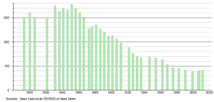
Population
The population of Dagonville has slowly declined since the beginning of census-taking in 1793; whereas the commune once housed as many as 356 people, as of 2011 it housed only 82. A more detailed list exists below, according to the École des Hautes Études en Sciences Sociales, a major French graduate school specializing in social sciences.
See also
| Wikimedia Commons has media related to Dagonville. |
This article is issued from
Wikipedia.
The text is licensed under Creative Commons - Attribution - Sharealike.
Additional terms may apply for the media files.