Vaux-devant-Damloup
| Vaux-devant-Damloup | |
|---|---|
| Commune | |
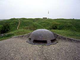 Fort de Vaux | |
 Vaux-devant-Damloup Location within Grand Est region  Vaux-devant-Damloup | |
| Coordinates: 49°12′44″N 5°28′24″E / 49.2122°N 5.4733°ECoordinates: 49°12′44″N 5°28′24″E / 49.2122°N 5.4733°E | |
| Country | France |
| Region | Grand Est |
| Department | Meuse |
| Arrondissement | Verdun |
| Canton | Belleville-sur-Meuse |
| Intercommunality | Communauté de communes de Charny-sur-Meuse |
| Government | |
| • Mayor (2008–2014) | Bernard Bertrand |
| Area1 | 6.56 km2 (2.53 sq mi) |
| Population (2012)2 | 67 |
| • Density | 10/km2 (26/sq mi) |
| Time zone | UTC+1 (CET) |
| • Summer (DST) | UTC+2 (CEST) |
| INSEE/Postal code | 55537 /55400 |
| Elevation |
244–361 m (801–1,184 ft) (avg. 270 m or 890 ft) |
|
1 French Land Register data, which excludes lakes, ponds, glaciers > 1 km2 (0.386 sq mi or 247 acres) and river estuaries. 2 Population without double counting: residents of multiple communes (e.g., students and military personnel) only counted once. | |
Vaux-devant-Damloup is a commune in the Meuse department in Grand Est in north-eastern France. It had a population of 67 (2012).
Fort Vaux is located on the territory of the commune.
It was one of the French villages destroyed during World War I, although it was rebuilt later.
See also
- Zone rouge (First World War)
- List of French villages destroyed in World War I
- Communes of the Meuse department
| Wikimedia Commons has media related to Vaux-devant-Damloup. |
This article is issued from
Wikipedia.
The text is licensed under Creative Commons - Attribution - Sharealike.
Additional terms may apply for the media files.