Monterey Park, New Mexico
| Monterey Park, New Mexico | |
|---|---|
| Census-designated place | |
 Monterey Park, New Mexico | |
| Coordinates: 34°45′04″N 106°39′11″W / 34.75111°N 106.65306°WCoordinates: 34°45′04″N 106°39′11″W / 34.75111°N 106.65306°W | |
| Country | United States |
| State | New Mexico |
| County | Valencia |
| Area[1] | |
| • Total | 2.6 sq mi (7 km2) |
| • Land | 2.6 sq mi (7 km2) |
| • Water | 0.0 sq mi (0 km2) |
| Elevation | 5,023 ft (1,531 m) |
| Population (2010)[2] | |
| • Total | 1,567 |
| • Density | 600/sq mi (230/km2) |
| Time zone | UTC-7 (Mountain (MST)) |
| • Summer (DST) | UTC-6 (MDT) |
| GNIS feature ID | 2630011[3] |
Monterey Park is a census-designated place in Valencia County, New Mexico, United States. Its population was 1,567 as of the 2010 census.[2] It is part of the Albuquerque Metropolitan Statistical Area.
The U.S. Census Bureau previously considered Monterey Park and the neighboring community of El Cerro Mission to be a single CDP, El Cerro-Monterey Park. The CDP was split prior to the 2010 Census.[4]
References
- ↑ "2010 Census Gazetteer Files". United States Census Bureau. Retrieved 2014-12-07.
- 1 2 "American FactFinder". United States Census Bureau. Retrieved 2014-12-07.
- ↑ "Monterey Park". Geographic Names Information System. United States Geological Survey.
- ↑ "2010 Place Relationship File". U.S. Census Bureau. Retrieved October 26, 2017.
Municipalities and communities of Valencia County, New Mexico, United States | ||
|---|---|---|
| Cities | 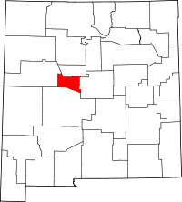 | |
| Town | ||
| Villages | ||
| CDPs | ||
| Unincorporated community | ||
This article is issued from
Wikipedia.
The text is licensed under Creative Commons - Attribution - Sharealike.
Additional terms may apply for the media files.