Las Maravillas, New Mexico
| Las Maravillas, New Mexico | |
|---|---|
| Census-designated place | |
 Las Maravillas, New Mexico | |
| Coordinates: 34°44′03″N 106°40′8″W / 34.73417°N 106.66889°WCoordinates: 34°44′03″N 106°40′8″W / 34.73417°N 106.66889°W | |
| Country | United States |
| State | New Mexico |
| County | Valencia |
| Area[1] | |
| • Total | 1.02 sq mi (2.65 km2) |
| • Land | 1.02 sq mi (2.64 km2) |
| • Water | 0.004 sq mi (0.01 km2) |
| Elevation | 5,023 ft (1,531 m) |
| Population (2010)[2] | |
| • Total | 1,628 |
| • Density | 1,592.9/sq mi (615.04/km2) |
| Time zone | UTC-7 (Mountain (MST)) |
| • Summer (DST) | UTC-6 (MDT) |
| GNIS feature ID | 2584133[3] |
Las Maravillas is a census-designated place in Valencia County, New Mexico, United States. Its population was 1,628 as of the 2010 census.[2]
Geography
Las Maravillas is located at coordinates 34°44′03″N 106°40′08″W / 34.73417°N 106.66889°W. According to the United States Census Bureau, Las Maracillas has a total area of 2.65 square kilometers, of which 2.64 km² is land and 0.01 km² is water.[1]
Demographics
According to the 2010 census,[2] 1628 people were living in Las Maravillas. The population density was 615.04 inhabitants per km². Of the 1628 inhabitants, Las Maravillas was composed by 79.48% White, 1.04% were African American, 2.33% were Native American, 0.61% were Asian, 0.31% were Pacific Islanders, 11.3% were of other races and 4.91% from two or more races. Of the total population 47.79% were Hispanic or Latino of any race.[4]
References
- 1 2 "2010 Census Gazetteer Files". United States Census Bureau. Retrieved September 19, 2016.
- 1 2 3 "American FactFinder". United States Census Bureau. Retrieved September 19, 2016.
- ↑ "Las Maravillas". Geographic Names Information System. United States Geological Survey.
- ↑ U.S. Board on Geographic Names
Municipalities and communities of Valencia County, New Mexico, United States | ||
|---|---|---|
| Cities | 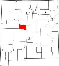 | |
| Town | ||
| Villages | ||
| CDPs | ||
| Unincorporated community | ||