Montenero d'Orcia
| Montenero d'Orcia | |
|---|---|
| Frazione | |
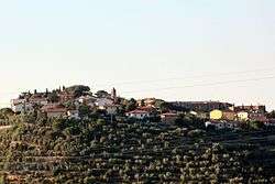 View of Montenero d'Orcia | |
 Montenero d'Orcia Location of Montenero d'Orcia in Italy | |
| Coordinates: 42°56′39″N 11°28′20″E / 42.94417°N 11.47222°ECoordinates: 42°56′39″N 11°28′20″E / 42.94417°N 11.47222°E | |
| Country |
|
| Region |
|
| Province | Grosseto (GR) |
| Comune | Castel del Piano |
| Elevation | 350 m (1,150 ft) |
| Population (2011) | |
| • Total | 243 |
| Demonym(s) | Montenerini |
| Time zone | UTC+1 (CET) |
| • Summer (DST) | UTC+2 (CEST) |
| Postal code | 58040 |
| Dialing code | (+39) 0564 |
Montenero d'Orcia is a village in Tuscany, central Italy, administratively a frazione of the comune of Castel del Piano, province of Grosseto, in the area of Mount Amiata. At the time of the 2001 census its population amounted to 253.[1]
Montenero is about 44 km from Grosseto and 14 km from Castel del Piano, and it is situated on a hill between the valley of Orcia and Ombrone rivers.
Main sights
.JPG)
The ancient pieve di Santa Lucia
- Pieve di Santa Lucia (12th century), main parish church of the village, with a wooden Crocefisso by Ambrogio Lorenzetti
- Church of Madonna (16th century), former church now deconsecrated
- Walls of Montenero, old fortifications which surround the village since the 10th century
- Cassero Senese, a 13th-century fortress, it was re-built in the 15th century
- Museum of Vine and Wine, little museum of local history about the traditions of grape growing and wine production in Montenero
References
Bibliography
- Aldo Mazzolai, Guida della Maremma. Percorsi tra arte e natura, Le Lettere, Florence, 1997
- Giuseppe Guerrini, Torri e castelli della Provincia di Grosseto, Nuova Immagine Editrice, Siena, 1999
See also
| Wikimedia Commons has media related to Montenero d'Orcia. |
This article is issued from
Wikipedia.
The text is licensed under Creative Commons - Attribution - Sharealike.
Additional terms may apply for the media files.