Molniya orbit
A Molniya orbit (Russian: Молния, IPA: [ˈmolnʲɪjə] (![]()
The high inclination of Molniya orbits provides a high angle of view to communications and monitoring satellites covering high latitudes. The high eccentricity provides a longer dwell time over the hemisphere of interest, compared to a more circular orbit. Geostationary orbits, which are necessarily inclined over the equator, can only view these regions from a low angle, and are unable to view latitudes above 81 degrees.[3]
History
The first use of the Molniya orbit was by the communications satellite series of the same name. After two launch failures in 1964, the first successful satellite to use this orbit, Molniya 1-01, launched on April 23, 1965. The early Molniya-1 satellites were primarily used for long-range military communications, but were also fitted with cameras used for weather monitoring and/or assessing clear areas for spy satellites.[4] The original Molniya satellites had a lifespan of approximately 1.5 years, as their orbits were disrupted by perturbations, and they had to be constantly replaced.[1]
Its successor, the Molniya-2, provided both military and civilian broadcasting, and was used to create the Orbita television network, spanning the Soviet Union. These were in turn replaced by the Molniya-3 design,[5] followed by the Mayak and Meridian satellites in 1997 and 2002 respectively.[6]
The Russian US-K early-warning satellites, which watch for US missile launches were launched in Molniya orbits from 1967, as part of the Oko system.[7][8][9]
From 1971, the American Jumpseat and Trumpet satellites were launched into Molniya orbits, and possibly used to strategically intercept Soviet communications from the Molniya satellites. Detailed information about both projects remains classified as of 2018.[6][10]
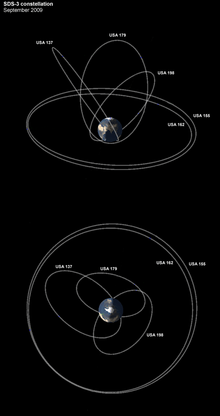
This was followed by the American SDS constellation, which operates with a mix of Molniya and geostationary orbits. These satellites are used to relay imagery from lower flying satellites back to ground stations in the United States and have been active in some capacity since 1976.[11] A single classified communication satellite launch in 1998 may be related to this constellation.[6]
A Russian satellite constellation called Nord (and later, Tyulpan) was designed to support mobile communications at high latitudes, in a similar manner to the Iridium constellation, but it did not progress past the planning phase.[12]
Uses
Much of the area of the former Soviet Union, and Russia in particular, is located at high latitudes. To broadcast to these latitudes from a geostationary orbit (above the Earth's equator) would require considerable power due to the low elevation angles. A satellite in a Molniya orbit is better suited to communications in these regions because it looks directly down on them during large portions of its orbit. With an apogee altitude as high as 40,000 km, and a sub-satellite point of 63.4 degrees north, it spends a considerable portion of its orbit with excellent visibility of the Northern Hemisphere, from the Russian Federation but also from Northern Europe, Greenland and Canada.[3]
While Molniya orbits require considerably less launch energy than geostationary orbits (especially from Russia),[13], the ground station needs a steerable antenna to track the spacecraft, links must be switched between satellites, the range is varying, there is a greater need for station keeping,[14][15][16] and the spacecraft will pass the Van Allen radiation belt four times per day.[13]
Properties
A typical Molniya orbit, has:
- Semi-major axis: 26,600 km
- Eccentricity: 0.74
- Inclination: 63.4°[15]
- Argument of perigee: 280°
- Period: 718 minutes[1]
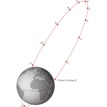
It is necessary to have a constellation of at least three spacecraft for permanent high elevation coverage of a large area, like the whole of Russia where some parts are as far south as 45° N. If three spacecraft are used, each spacecraft is active for periods of eight hours per orbit centered at apogee[3] as illustrated in figure 9.
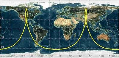
The Earth completes half a rotation in 12 hours, so the apogees of successive Molniya orbits will alternate between one half of the northern hemisphere and the other. For the original Molniya orbit, this places the apogees over Russia and Canada, but by changing the right ascension of the ascending node this could be varied. For example, if the apogee longitudes are 90° E and 90° W, the apogees will alternately serve Europe and Asia (see figures 3 to 5) and next North America (see figures 6 to 8).
The orbits of the three spacecraft should then have the same orbital parameters, but different right ascension of the ascending nodes, with their passes over the apogees (for example 90° W and 90° E) separated by 7.97 hours.[3][17] Since each satellite has an operational period of 8 hours, when one spacecraft travels four hours after its apogee passage (see figure 5 or figure 8), the next satellite will enter it's operational period. The next satellite will have a view of the earth shown in figure 3 (or figure 6) and the switch-over can take place. Note that the two spacecraft at the time of switch-over are separated about 1500 km, so that the ground stations only have to move the antennas a few degrees to acquire the new spacecraft.[18]
Orbital inclination
In general, the oblateness of the Earth perturbs the argument of perigee ( ), so that even if the apogee started near the north pole, it would gradually move, according to equation 1, unless constantly corrected with station-keeping thruster burns.

-
(1)

where is the gravitational constant, is the perturbing factor, and is the semi-latus rectum.


To avoid this expenditure of fuel, the Molniya orbit uses an inclination of 63.4°, for which these perturbations are zero.[14][15] At this inclination the factor is zero, so there is no change in perigee over time.

Orbital period
To ensure the geometry relative to the ground stations repeats every 24 hours the nodal period should be about half a sidereal day, keeping the longitudes of the apogees passages constant.
However, the oblateness of the Earth also perturbs the right ascension of the ascending node ( ), which would cause the ground track to drift over time at the rate shown in equation 2.

-
(2)

Since the inclination of a Molniya orbit is set, this perturbation is degrees per orbit. To compensate, the orbital period is adjusted so that the longitude of the apogee changes enough to cancel out this effect.[15]

Eccentricity
The eccentricity of the orbit is based on the differences in altitudes of its apogee and perigee. To maximise the amount of time that the satellite spends over the apogee the eccentricity should be as high as possible.
However, the perigee needs to be high enough to keep the satellite above the atmosphere to avoid drag, and the orbital period needs to be approximately half a sidereal day. These two factors constrain the eccentricity, which becomes approximately 0.737.[15]
Modelling
To track satellites using Molniya orbits, scientists use the SDP4 simplified perturbations model, which calculates the location of a satellite based on orbital shape, drag, radiation, gravitation effects from the sun and moon, and earth resonance terms.[19]
Diagrams


See also
References
- 1 2 3 Kolyuka, Yu. F.; Ivanov, N.M.; Afanasieva, T.I.; Gridchina, T.A. (28 September 2009). Examination of the Lifetime, Evolution and Re-Entry Features for the "Molniya" Type Orbits (PDF). 21st International Symposium of Space Flight Dynamics. Toulouse, France: Mission Control Center 4, Korolev, Moscow. p. 2. Retrieved 22 May 2018.
- ↑ Anatoly Zak. "Russian communications satellites". Russian Space Web. Retrieved 22 May 2018.
- 1 2 3 4 Stojče Dimov Ilčev. Global Satellite Meteorological Observation (GSMO) Theory, Volume 1. Springer International Publishing. p. 57. ISBN 978-3-319-67119-2.
- ↑ Hendrickx, Bart. "A History of Soviet/Russian Meteorological Satellites" (PDF). Bis-Space.com. Antwerpen, Belgium. p. 66.
- ↑ Martin, Donald H. (2000). Communication Satellites. AIAA. pp. 215–. ISBN 9781884989094. Retrieved 1 January 2013.
- 1 2 3 Mark Wade. "Molniya orbit". Astronautix. Retrieved 6 June 2018.
- ↑ Forden, Geoffrey (May 3, 2001). "Reducing a Common Danger: Improving Russia's Early-Warning System" (PDF). Cato Policy Analysis No. 399. Cato Institute: 5.
- ↑ Podvig, Pavel (2002). "History and the Current Status of the Russian Early-Warning System" (PDF). Science and Global Security. 10: 21–60. doi:10.1080/08929880212328. ISSN 0892-9882. Archived from the original (pdf) on 2012-03-15.
- ↑ "Russia blinded by loss of missile detection satellite". Moscow Times. 26 June 2014.
- ↑ William Graham (23 September 2017). "Atlas V launches NROL-42 spy satellite". NASA spaceflight.
- ↑ Jeffrey T Richelson (2002). The Wizards of Langley. Inside the CIA's Directorate of Science and Technology. Boulder: Westview press. ISBN 0813340594.
- ↑ Anatoly Zak. "Nord:Connecting the north". Russian Space Web. Retrieved 6 June 2018.
- 1 2 "Soviet orbital trick". Geek Times. Retrieved 23 May 2018.
- 1 2 Wiley J. Larson and James R. Wertz (ed.). Space Mission Analysis and Design. Microcosm.
- 1 2 3 4 5 Kidder, Stanley Q.; Vonder Haar, Thomas H. (18 August 1989). "On the Use of Satellites in Molniya Orbits of Meteorological Observation of Middle and High Latitudes". Journal of Atmospheric and Oceanic Technology. 7. p. 517.
- ↑ King-Hele, D. G. (1975). "The Orbital Lifetime of Molniya Satellites". Jbis-journal of The British Interplanetary Society. 28: 783–796.
- ↑ Kidder, Stanley Q.; Vonder Haar, Thomas H. (18 August 1989). "On the Use of Satellites in Molniya Orbits of Meteorological Observation of Middle and High Latitudes". Journal of Atmospheric and Oceanic Technology. 7. p. 519.
- ↑ R. L. Sturdivant, E. K. P. Chon (2016). "Systems Engineering of a Terabit Elliptic Orbit Satellite and Phased Array Ground Station for IoT Connectivity and Consumer Internet Access". IEEE. 4: 9947.
- ↑ Hoots, Felix R.; Ronald L. Roehrich (31 December 1988). "Models for Propagation of NORAD Element Sets" (PDF). United States Department of Defense Spacetrack Report (3). Retrieved 16 June 2010.