Mole (architecture)
A mole is a massive structure, usually of stone, used as a pier, breakwater, or a causeway between places separated by water. The word comes from Middle French mole, ultimately from Latin mōlēs, meaning a large mass, especially of rock; it has the same root as molecule and mole, the chemical unit of measurement.[2] A mole may have a wooden structure built on top of it that resembles a wooden pier. The defining feature of a mole, however, is that water cannot freely flow underneath it, unlike a true pier. The oldest known mole is at Wadi al-Jarf, an ancient Egyptian harbor complex on the Red Sea.
San Francisco Bay Area
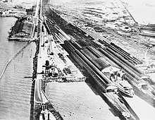
In the San Francisco Bay Area in California, there were several moles, combined causeways and wooden piers or trestles extending out from the eastern shore and utilized by various railroads, such as the Key System, Southern Pacific Railroad (two), and Western Pacific Railroad: the Alameda Mole, the Oakland Mole, and the Western Pacific Mole. By extending the tracks the railroads could get beyond the shallow mud flats and reach the deeper waters of the Bay that could be navigated by the Bay Ferries. A train fell off the Alameda Mole through an open drawbridge in 1890 killing several people.[3] None of the four Bay Area moles survive today, although the causeway portions of each were incorporated into the filling in of large tracts of marshland for harbor and industrial development.
A large mole was completed in 1947 at the San Francisco Naval Shipyard in the Bayview-Hunters Point neighborhood of San Francisco to accommodate the large Hunters Point gantry crane. The mole required 3,000,000 cubic yards (2,300,000 m3) of fill.[4]
World War II
Dunkirk evacuation
The two concrete moles protecting the outer harbour at Dunkirk played a significant part in the evacuation of British and French troops during World War II in May/June 1940. The harbour had been made unusable by German bombing and it was clear that troops were not going to be taken directly off the beaches fast enough. Naval captain W. G. Tennant had been placed ashore to take charge of the navy shore parties and organise the evacuation. Tennant had what proved to be the highly successful idea of using the East Mole to take off troops. The moles had never been designed to dock ships, but despite this, the majority of troops rescued from Dunkirk were taken off in this way.[5]
Churchill Barriers
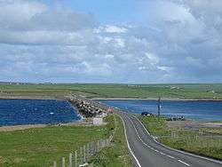
The Churchill Barriers are a series of four causeways in the Orkney Islands with a total length of 1.5 miles (2.4 km). They link the Orkney Mainland in the north to the island of South Ronaldsay via Burray and the two smaller islands of Lamb Holm and Glimps Holm.
The barriers were built in the 1940s as naval defences to protect the anchorage at Scapa Flow. They were commissioned following the sinking of HMS Royal Oak in 1939 by German U-boat U-47 which had penetrated the existing defences of sunken blockships and anti-submarine nets. The barriers now serve as road links, carrying the A961 road from Kirkwall to Burwick.
Heptastadion
Notable in antiquity was the Heptastadion, a giant mole[6] built in the 3rd century BC in the city of Alexandria, Egypt[7] to join the city to Pharos Island where the Pharos lighthouse stood.[8] The causeway formed a barrier separating Alexandria's oceanfront into two distinct harbours,[9] an arrangement which had the advantage of protecting the harbours from the force of the strong westerly coastal current.[10] The Heptastadion is also believed to have served as an aqueduct while Pharos was inhabited,[11] and geophysical research indicates that it was part of the road network of the ancient city.[12] Silting over the years[6] resulted in the former dyke disappearing under several metres of accumulated silt and soil[13] upon which the Ottomans built a town from 1517 onwards.[12] Part of the modern city of Alexandria is now built on the site.
English Tangier
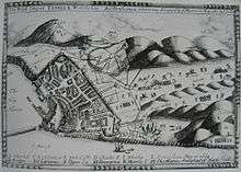
When England acquired the north African city of Tangier as English Tangier in 1661, the English began building a mole to improve the harbour. The mole was planned to be 1,436 feet (438 m) long and cost £340,000, and the improved harbour was to be 600 yd (550 m) long, 30 ft (9 m) deep at low tide, and capable of keeping out the roughest of seas.[14] Work began on the mole in August 1663[15] and continued for some years under a succession of Governors. With an improved harbour the town would have played the same role that Gibraltar later played in British naval strategy.[16] However, Parliament expressed concern about the cost of maintaining the Tangier garrison, and by 1680 King Charles II had threatened to give up Tangier unless the supplies were voted for its sea defences. A crippling blockade by the Jaysh al-Rifi finally forced the English to withdraw from Tangier in 1683. The King gave secret orders to abandon the city, level the fortifications, destroy the harbour, and evacuate the troops. Samuel Pepys was present at the evacuation and wrote an account of it.[17]
Stone quaysides

Stone quaysides are sometimes called moles. A well-known example is the Molo in Venice. It is the site of the Doge's Palace and two pillars which form a gateway to the sea.[18] It has been depicted numerous times by artists such as Canaletto.
Gallery
See also
References
- ↑ "Vidzeme coastline", Official Latvian Tourist Portal, retrieved 9 January 2011.
- ↑ John Simpson (ed), "mole, n.2", Oxford English Dictionary Online, retrieved 8 January 2011.
- ↑ Lawrence M. Friedman, "Civil wrongs: personal injury law in the late 19th century", Law & Social Inquiry, vol. 12, iss. 2-3, pp. 351–378, April 1987, p. 374.
- ↑ Stimson Jr., Thomas E. (September 1947). "Spanning the Navy's Mole at Hunter's Point, Calif., is the World's Largest Crane". Popular Mechanics. Vol. 88 no. 3. pp. 124–128, 256. ISSN 0032-4558. Retrieved 28 December 2017.
- ↑ "Operation Dynamo, the evacuation from Dunkirk, 27 May-4 June 1940", Military History Encyclopedia on the Web, retrieved 8 January 2011.
- 1 2 Pearson, Birger Albert (2004). Gnosticism and Christianity in Roman and Coptic Egypt. Continuum International Publishing Group. p. 104. ISBN 0-567-02610-8.
- ↑ Khalid S. Al-Hagla. "Cultural Sustainability: An Asset of Cultural Tourism Industry" (PDF). International Cetre for Research on the Economics of Culture, Institutions, and Creativity (EBLA). Archived from the original (PDF) on 2007-07-21.
- ↑ Smith, Sir William (1952). Everyman's Smaller Classical Dictionary. J. M. Dent & Sons Ltd. p. 222.
- ↑ Arthur de Graauw. "Ancient Ports – Ports Antiques: Alexandria". www.ancientportsantiques.com. Retrieved 17 July 2015.
- ↑ "Egypt After the Pharaohs: Heptastadion". www.brown.edu. Brown University. Retrieved 17 July 2015.
- ↑ Bertrand Millet; Goiran, Jean-Philippe (2007). "Impacts of Alexandria's Heptastadion on Coastal Hydro-Sedimentary Dynamics During the Hellenistic Period". The International Journal of Nautical Archaeology. 36 (1): 167–176. doi:10.1111/j.1095-9270.2006.00131.x.
- 1 2 "Archaeologists and Geophysicists: The Heptastadion". www.cealex.org. Centre d'Études Alexandrines. Retrieved 17 July 2015.
- ↑ "The Ptolemaic Legacy". Archived from the original on 2008-02-16. Retrieved 2008-02-11.
- ↑ GIS-based plans of the historic harbour and of its works, prepared from English and Portuguese documents, are available in Elbl, Portuguese Tangier (the plans show all the data in modern coordinates).
- ↑ Sir Hugh Cholmley. "A Short account of the progress of the mole at Tangier". Early English Books Online – Text Creation Partnership. Retrieved 29 December 2015.
- ↑ Enid M. G. Routh — Tangier: England's lost Atlantic outpost, 1912; Martin Malcolm Elbl, "(Re)claiming Walls: The Fortified Médina of Tangier under Portuguese Rule (1471–1661) and as a Modern Heritage Artefact," Portuguese Studies Review 15 (1–2) (2007; publ. 2009): 103–192; a long study of the previous Portuguese Breakwater at Tangier, and interesting notes on the English Mole and its contractors are found in Elbl, Portuguese Tangier, Chapter Eight.
- ↑ John Wreglesworth, Tangier: England's Forgotten Colony (1661-1684) at elsewhereonline.com.au, accessed 28 February 2011 Archived 5 September 2008 at the Wayback Machine.
- ↑ Manfredo Tafuri, Venice and the Renaissance, page 25, MIT Press, 1995. ISBN 0262700549.