Moldova–Ukraine border
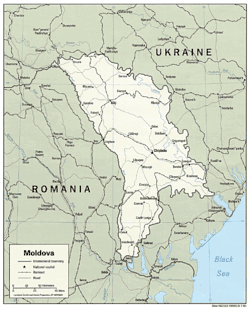
The modern Moldova–Ukraine border, the official border between Republic of Moldova and Ukraine, was established after the dissolution of the Soviet Union. The length of the inland border is 1222 km,[1] of which 267 km is fluvial (i.e., along rivers) and 955 is land border.[2] About 454 km of it constitutes the de-facto border between Ukraine and unrecognized breakaway republic of Transnistria.[2]
The border runs from the northern Romania-Moldova-Ukraine tripoint in the northwest of the country, 4km from the Ukrainian village and border crossing of Mamalyha, Ukraine to Criva, Briceni, Moldova. It runs east until the city and border crossing of Mohyliv-Podilskyi, where it turns southeast and enters the channel of the river of Dniester. By the village of Nimereuca the territory of Transnistria begins, which ends by Purcari. Several kilometers further it turns west. By Basarabeasca District it turns south and runs until the southern Romania-Moldova-Ukraine tripoint near Galați, Romania and Reni, Ukraine, by Danube.
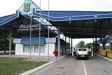
As of 2014 the border had 67 permanent official border crossings classified into 3 categories: international, for crossing by citizens of any state; interstate, for crossing only by citizens of Moldova and Ukraine; and local, for local border traffic. Of them 25 crossing are along the Transnistria–Ukraine border and not monitored by the Moldovan border guards.[2]
There is a unique disputed situation with the Moldovan village of Palanca, Ștefan Vodă. As of 2014 its territory abuts to Odessa Oblast of Ukraine in such a way that there is no way to move to the southern part of Odessa Oblast from the rest of Ukraine by land without crossing Moldova;[2] see Palanca, Ștefan Vodă: Border dispute for more.