Belarus–Ukraine border

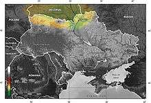
Belarusian-Ukrainian border is the state border between Belarus and Ukraine with a length of about 1,084 km (674 mi). It starts from the triple junction with Poland[1] to the west and stretches to the triple junction with Russia[2] to the east. The tripoint border at the triple border junction of Belarus, Russia and Ukraine is marked in the form of a monument, while at the other border junction there is a river Western Bug that coincides with the border of Poland.
Geography
The border is situated in a geographic region of Polesia (Polesian Lowland) that stretches approximately from Western Bug to Dnieper along Prypiat River (just to the south of it). It is part of bigger East European Plain and known for its Pripet Marshes[3] (or Pinsk Marshes).
The west end of the border starts at Western Bug around the area of lakes of Shatsk and runs eastward across the Pinsk Marshes. Further it stretches parallel to Pripyat River some distance south from it passing densely wooded areas that were contaminated after the Chernobyl disaster. The border passes Pripyat just to the north of Pripyat city and then also turns southeast as the river and continues to run parallel to it. As the border reaches Dnieper, it turns north towards Homiel and runs along the river. At the midpoint between Homiel and a town of Ripky, the border turns and again runs eastward towards Central Russian Upland for about 100 km (62 mi) where it terminates at triple junction point with Russian border.
History
The modern state of the border is dated to World War I when in 1918 on the map of the world appeared the Ukrainian People's Republic.
However, the border has historical roots. The border was similar between the Grand Duchy of Lithuania and the Kingdom of Poland according to the Union of Lublin. It corresponded to administrative border of Brest-Litovsk and Minsk voivodeship on the Lithuanian side and Kiev, Volhynian, and Ruthenian voivodeships on the Polish side.
After the World War I and treaty of Riga the western portion of the border roughly coincided with administrative border of Polesia and Volyn provinces of interwar Polish Republic, and in the eastern – the Soviet republics of Belarus and Ukraine.
At first, the border between the both Soviet republics was recognized by the Treaty between the Ukrainian SSR and Belarusian SSR from December 12, 1990.
Status of the state border with Ukraine was given by the Supreme Soviet of Belarus of 11 June 1993, but there is an international agreement between Belarus and Ukraine, in which they mutually recognize the border BSSR and USSR recognized in 1990.
To date, the border is governed by the Agreement between Belarus and Ukraine on friendship, good neighborliness and the cooperation of 17 June 1995, the Treaty on the State Border between Belarus and Ukraine on 12 May 1997 in the same year was ratified by the Verkhovna Rada of Ukraine, and in 2010 the National Assembly of Belarus, but the parties still have not exchanged instruments of ratification.
According to Chairman of the State Border Committee of Belarus, Igor Raczkowski, work on border demarcation may continue up to 10 years and require 51 billion rubles.[4]
Demarcation of the border began with the 13 November 2013 inauguration of the first border sign in the place of convergence of state borders of Ukraine, Belarus and Russia.[5]
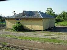
Following the Chernobyl disaster in 1986, a big portion of the border lays with the so-called Chernobyl Exclusion Zone (Ukrainian side) and Polesie State Radioecological Reserve (Belarusian side). The Chernobyl Exclusion Zone in Ukraine is governed by the Ministry of Ecology and Natural Resources through its special agency. The area does not have adequate infrastructure for border crossing which is conducted in the area under special authority due to contamination. The exclusion zone itself has own checkpoints. Along the border on Ukrainian side stretches Chernihiv–Ovruch railway connecting the abandoned Chernobyl Nuclear Power Station with the city of Slavutych. It railroad crosses Belarus-Ukrainian twice.
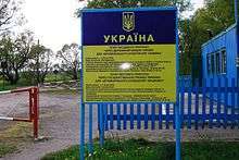
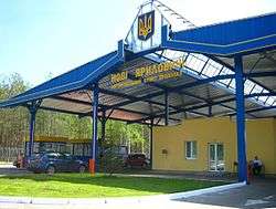
Border checkpoints
| Ovruch to Chernihiv Line | |||||||||||||||||||||||||||||||||||||||||||||||||||||||||||||||||||||||||||||||||||||||||||||||||||||||||||||||||||||||||||||||||||||||||||||||||||||||||||||||||||||||||||||||||||||||||||||||||||||||||||||||||||||||||||||||||||||||||||||||||||||||||||||||||||||||||||||||||||||||||||||||||||||||
|---|---|---|---|---|---|---|---|---|---|---|---|---|---|---|---|---|---|---|---|---|---|---|---|---|---|---|---|---|---|---|---|---|---|---|---|---|---|---|---|---|---|---|---|---|---|---|---|---|---|---|---|---|---|---|---|---|---|---|---|---|---|---|---|---|---|---|---|---|---|---|---|---|---|---|---|---|---|---|---|---|---|---|---|---|---|---|---|---|---|---|---|---|---|---|---|---|---|---|---|---|---|---|---|---|---|---|---|---|---|---|---|---|---|---|---|---|---|---|---|---|---|---|---|---|---|---|---|---|---|---|---|---|---|---|---|---|---|---|---|---|---|---|---|---|---|---|---|---|---|---|---|---|---|---|---|---|---|---|---|---|---|---|---|---|---|---|---|---|---|---|---|---|---|---|---|---|---|---|---|---|---|---|---|---|---|---|---|---|---|---|---|---|---|---|---|---|---|---|---|---|---|---|---|---|---|---|---|---|---|---|---|---|---|---|---|---|---|---|---|---|---|---|---|---|---|---|---|---|---|---|---|---|---|---|---|---|---|---|---|---|---|---|---|---|---|---|---|---|---|---|---|---|---|---|---|---|---|---|---|---|---|---|---|---|---|---|---|---|---|---|---|---|---|---|---|---|---|---|---|---|---|---|---|---|---|---|---|---|---|---|---|---|---|---|---|
| |||||||||||||||||||||||||||||||||||||||||||||||||||||||||||||||||||||||||||||||||||||||||||||||||||||||||||||||||||||||||||||||||||||||||||||||||||||||||||||||||||||||||||||||||||||||||||||||||||||||||||||||||||||||||||||||||||||||||||||||||||||||||||||||||||||||||||||||||||||||||||||||||||||||
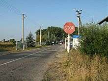
Checkpoints in bold have international status.
Homiel – Chernihiv regions
- Loyew – Kamianka (river, in winter – ice crossing)
- Andzewka – Derevyny (small road/street, local traffic passengers during day hours)
- Paddabranka – Dobryanka (small road/street, local traffic passengers during day hours)
- Hlybotskaie – Ilmivka (small road/street, local traffic passengers during day hours)
- Kamaryn – Slavutych P35/P56
- Vesialowka – Senkivka P124/P13
- Novaja Huta – Novi Yarylovychi

- Cierucha – Hornostayivka (railway) (Chernihiv (railway, f))
- Cierachowka – Khorobychi (railway) (Shchors (railway))
Homiel – Kiev regions
- (S) Aliaksandrawka – Vilcha P37/T1035 (within Chornobyl zone)
Homiel – Zhytomyr regions
- (S) Hluškavičy – Maidan Kopyshchansky P36/T0605
- Novaja Rudnia – Vystupovychi P31/P28 (within Chornobyl zone)
- Slavečna – Vystupovychi (railway, within Chornobyl zone) (Ovruch (railway) and Korosten (railway))
Bresc – Rivne regions
- Trušava – Vychivka (small road/street, local traffic passengers during day hours)
- Aĺmany – Perebrody (small road/street, local traffic passengers during day hours)
- (S) Nievieĺ – Prykladnyky P147/P76
- Vierchni Cierabiažow – Horodyshche P88/P05
- Haryń – Udrytsk (railway) (Sarny (railway))
Bresc – Volyn regions
- Očyna – Huta (small road/street, local traffic passengers during day hours)
- Sušytnica – Tur (small road/street, local traffic passengers during day hours)
- Dubok – Khrypsk (small road/street, local traffic passengers during day hours)
- (S) Dzivin – Samary P127/local road
- Tamašowka – Pulemets P94/T0307 – (S) Oltuš – Pishcha P17/T0307 (area of lakes of Shatsk)
- Machro – Dolsk P144/P14
- Makrany – Domanove


- Chacislaw – Zabolottia (railway) (Kovel (railway, freight))
Special case (Chernobyl railroad)
Please, note that Chernihiv–Ovruch railway is used by Ukrzaliznytsia only. The railroad passes through number of train stations on Belarus territory most of which are abandoned except for the Iolcha train station. Iolcha train station is leased by the government of Ukraine and operated by Ukrainian personnel, while the border services (such as customs) are conducted by the Belarusian authorities. Border services on Ukrainian territory also conducted at train stations Semykhody, Ivankiv Raion (near Prypiat) and Nedanchychi, Ripky Raion (near Slavutych). The portion of railroad between Semykhody and Ovruch is suspended indefinitely and not being utilized.
References
- ↑ Note: See also Category:Belarus–Poland border and Category:Poland–Ukraine border
- ↑ Note: See also Belarus–Russia border and Poland–Russia border
- ↑ Pripet Marshes. Encyclopædia Britannica.
- ↑ Екатерина Нечаева. Для демаркации белорусско-украинской границы потребуется до десяти лет // BELTA, January 19, 2010
- ↑ Торжественно открыт первый пограничный знак
External links
- Schematic map of the Southwestern Railway. Southwestern Railway website.
- Schematic map of the Lviv Railway. Lviv Railway website.
- List of border checkpoints. State Border Service of Ukraine website.