Moculta, South Australia
| Moculta South Australia | |||||||||||||||
|---|---|---|---|---|---|---|---|---|---|---|---|---|---|---|---|
 Gnadenberg Church and the Hill of Grace wineyard | |||||||||||||||
 Moculta | |||||||||||||||
| Coordinates | 34°28′12″S 139°07′02″E / 34.470134°S 139.117288°ECoordinates: 34°28′12″S 139°07′02″E / 34.470134°S 139.117288°E[1] | ||||||||||||||
| Population | 227 (shared with part of Truro) (2016 census)[2][lower-alpha 1] | ||||||||||||||
| Established |
1842 (sub-division) 15 May 2003[1][3] | ||||||||||||||
| Postcode(s) | 5353[4] | ||||||||||||||
| Time zone | ACST (UTC+9:30) | ||||||||||||||
| • Summer (DST) | ACST (UTC+10:30) | ||||||||||||||
| Location | |||||||||||||||
| LGA(s) | Barossa Council[1] | ||||||||||||||
| County | Light[1] | ||||||||||||||
| State electorate(s) | Schubert | ||||||||||||||
| Federal Division(s) | Barker | ||||||||||||||
| |||||||||||||||
| |||||||||||||||
| Footnotes |
Location[4] Adjoining localities[1] | ||||||||||||||
Moculta is a locality in the Australian state of South Australia located about 69 kilometres (43 mi) north-east of the state capital of Adelaide and about 12 kilometres (7.5 mi) north-east of the municipal seat of Angaston.[1][4] At the 2016 census, Moculta shared a population of 227 with part of Truro).[2]
The earliest settlers in the area were English, Scottish and Irish migrants. German migrants also came to the area from 1853. They built both the Gruenberg (1859) and Gnadenberg Lutheran churches. The township of Moculta itself was surveyed in 1865 and occupied soon after.[6]
The locality of Grünberg was renamed to Karalta as a consequence of the move to rename "names of enemy origin" during World War I, but has been named back to the anglicised Gruenberg since then. It is now included in Moculta and Penrice[7] Gnadenberg is also now included in Moculta.[8]
Gallery
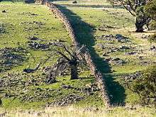 A dry stone wall at Mt Karinya near Moculta, South Australia.
 A dry stone wall at Mt Karinya near Moculta, South Australia.
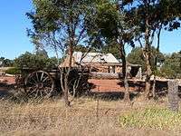 The restored cottage of the Rosenzweig's at Moculta, built circa 1859 with farm equipment in the foreground.
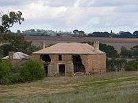 The ruins of the Shannon family's farmhouse at Moculta in 2006. The steeple of the Gruenberg Lutheran church can be seen in the background.
 The Shannon family mausoleum outside of Moculta, South Australia.
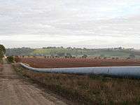 The Swan Reach to Stockwell Pipeline at Moculta, South Australia.
References
| Wikimedia Commons has media related to Moculta, South Australia. |
- Notes
- ↑ For the 2016 census, the ‘State Suburb of Moculta’ consisted of the locality of Moculta and the part of Truro within the Barossa Council and which is bounded by the Sturt Highway to the north.
- Citations
- 1 2 3 4 5 6 "Search results for 'Moculta, LOCB' with the following datasets being selected - 'Suburbs and Localities', 'Counties', 'Local Government Areas', 'SA Government Regions' and 'Gazetteer'". Location SA Map Viewer. Government of South Australia. Retrieved 18 April 2018.
- 1 2 Australian Bureau of Statistics (27 June 2017). "Moculta". 2016 Census QuickStats. Retrieved 18 April 2018.

- ↑ Weatherill, Jay (15 May 2003). "GEOGRAPHICAL NAMES ACT 1991 Notice to Assign Names and Boundaries to Place (within the Barossa Council)" (PDF). The South Australian Government Gazette. South Australian Government. p. 1947. Retrieved 18 April 2018.
- 1 2 3 "Moculta, South Australia (postcode)". postcodes-australia.com. Retrieved 4 February 2017.
- 1 2 3 "Monthly climate statistics: Summary statistics: NURIOOTPA PIRSA (nearest weather station)". Commonwealth of Australia , Bureau of Meteorology. Retrieved 4 February 2017.
- ↑ "Moculta". Flinders Ranges Research. Retrieved 9 February 2015.
- ↑ "Placename Details: Gruenberg". Department of Planning, Transport and Infrastructure, Government of South Australia. 2 November 2012. SA0028183. Retrieved 10 January 2015.
Previously spelt as Grunberg. Gruenberg is German meaning green hill. Name altered to Karalta. Gruenberg reinstated. Not to be used as an address and is now incorporated in the bounded localities of Moculta and Penrice.
- ↑ "Placename Details: Gnadenberg". Department of Planning, Transport and Infrastructure, Government of South Australia. 22 August 2006. SA0004793. Retrieved 10 January 2015.