Mizoch

Mizoch (Ukrainian: Мізоч, Russian: Мизоч, Polish: Mizocz, Yiddish: מיזאָטש) is an urban-type settlement in Zdolbuniv Raion, Rivne Oblast, Ukraine, 30 km far from Rivne. Its population was 3,541 (2017 est.)[1].
History
The first written record goes back to 1322. The confirmation of the city's legal status dates from 1429. In 1761 the King Augustus III of Poland granted Mizocz the Magdeburg Rights. The civic self-government placed the city Velykyi Mizoch (Greater Mizoch) in the Luts'k district. Between world wars, Mizocz was a multi-ethnic community like many others in eastern Poland, inhabited by Jews, Poles, and Ukrainians. There was a military school in Mizocz for the officer cadets of the Battalion 11 of the Polish Army's First Brigade;[2] the Karwicki Palace (built in 1790, partly destroyed by the Bolsheviks in 1917), Hotel Barmocha Fuksa,[3] a Catholic and an Orthodox church, and a Synagogue. The nearest major city was Równo.[2]
In World War II, the town was invaded twice. It fell under the Nazi occupation in 1941. The Jewish inhabitants were first forced into the newly formed Mizocz Ghetto, from which they were taken out and slaughtered at a nearby ravine.[4][5] After the dissolution of the Soviet Union, the Gonfalon and modern emblem was approved by the city council on September 11, 1996.
Gallery
 Polish–Lithuanian Commonwealth Emblem, Wielki Mizocz (W-M)
 Watchtower of the Polish military school for the officer cadets, 1925
 Present-day Emblem
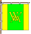
 Roadsign
References
- ↑ "Чисельність наявного населення України (Actual population of Ukraine)" (in Ukrainian). State Statistics Service of Ukraine. Retrieved 26 August 2017.
- 1 2 Andrzej Mielcarek, Wołyń (May 2006). "Miasteczko Mizocz". Instytut Kresowy. Strony o Wołyniu. Retrieved 19 April 2015.
- ↑ Wołyń (2015). "Miasteczko Mizocz" (also in: Ilustrowany przewodnik po Wołyniu by Dr Mieczysław Orłowicz, Łuck 1929). Roman Aftanazy, "Dzieje rezydencji na dawnych kresach Rzeczypospolitej", Vol. 5, Województwo wołyńskie", 1994, pp. 247-253. Wołyń - przegląd. Retrieved 19 April 2015.
- ↑ Jewish Communities in Volhynia, JewishGen Database, New York.
- ↑ Struck, Janina, Photographing the Holocaust, I. B. Tauris, at pp. 72-73. ISBN 1860645461
External links
| Wikimedia Commons has media related to Mizoch. |
| Raions | |||||
|---|---|---|---|---|---|
| Cities |
| ||||
| |||||