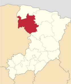
Volodymyrets Raion
| Volodymyrets Raion Володимирецький район | |||
|---|---|---|---|
| Raion | |||
| |||
 | |||
| Coordinates: 51°27′7″N 26°1′35″E / 51.45194°N 26.02639°ECoordinates: 51°27′7″N 26°1′35″E / 51.45194°N 26.02639°E | |||
| Country |
| ||
| Region |
| ||
| Established | 1939 | ||
| Admin. center | Volodymyrets | ||
| Subdivisions |
List
| ||
| Area | |||
| • Total | 1,940 km2 (750 sq mi) | ||
| Population | |||
| • Total | 64,975 | ||
| • Density | 33/km2 (87/sq mi) | ||
| Time zone | UTC+2 (EET) | ||
| • Summer (DST) | UTC+3 (EEST) | ||
| Area code | +380 | ||
| Website | Volodymyrets Raion | ||
Volodymyrets Raion (Ukrainian: Володимирецький район) is a raion in Rivne Oblast in western Ukraine. Its administrative center is the urban-type settlement of Volodymyrets. Population: 64,975 (2017 est.)[1]
See also
References
- ↑ "Чисельність наявного населення України (Actual population of Ukraine)" (in Ukrainian). State Statistics Service of Ukraine. Retrieved 26 August 2017.
External links
- rv.gov.ua (in Ukrainian)
| Raions | |||||
|---|---|---|---|---|---|
| Cities |
| ||||
| |||||
This article is issued from
Wikipedia.
The text is licensed under Creative Commons - Attribution - Sharealike.
Additional terms may apply for the media files.