Mistelgau
| Mistelgau | ||
|---|---|---|
| ||
 Mistelgau Location of Mistelgau within Bayreuth district 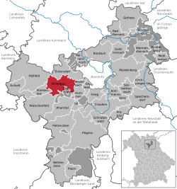 | ||
| Coordinates: 49°55′N 11°28′E / 49.917°N 11.467°ECoordinates: 49°55′N 11°28′E / 49.917°N 11.467°E | ||
| Country | Germany | |
| State | Bavaria | |
| Admin. region | Oberfranken | |
| District | Bayreuth | |
| Municipal assoc. | Mistelgau | |
| Government | ||
| • Mayor | Georg Birner | |
| Area | ||
| • Total | 39.43 km2 (15.22 sq mi) | |
| Elevation | 435 m (1,427 ft) | |
| Population (2017-12-31)[1] | ||
| • Total | 3,789 | |
| • Density | 96/km2 (250/sq mi) | |
| Time zone | CET/CEST (UTC+1/+2) | |
| Postal codes | 95490 | |
| Dialling codes | 09279 | |
| Vehicle registration | BT | |
| Website | www.mistelgau.de | |

Mistelgau is a municipality in the district of Bayreuth in Bavaria in Germany.
It consists of the following 41 districts: Äußerer Graben, Außerleithen, Böhnershof, Braunersberg, Culm obere, Culm untere, Engelmeß, Eschenmühle, Frankenhaag, Friedrichsruh, Geislareuth, Gollenbach, Göritzen, Gries, Hardt, Harloh, Hundshof, Kammer, Klingenmühle, Kreckenmühle, Laimen, Lenz, Mengersdorf, Mistelgau, Moosing, Obernsees, Ochsenholz, Pensenleithen, Plösen, Schnackenwöhr, Schobertsberg, Schobertsreuth, Schöchleins, Seitenbach, Sorg, Streit, Striegelhof, Tennig, Truppach, Wohnsgehaig.[2]
References
- ↑ "Fortschreibung des Bevölkerungsstandes". Bayerisches Landesamt für Statistik und Datenverarbeitung (in German). September 2018.
- ↑ "Mistelgau" (in German). Bayerische Landesbibliothek Online. Retrieved 4 March 2018.
This article is issued from
Wikipedia.
The text is licensed under Creative Commons - Attribution - Sharealike.
Additional terms may apply for the media files.