Hollfeld
| Hollfeld | ||
|---|---|---|
| ||
 Location of within Bayreuth district 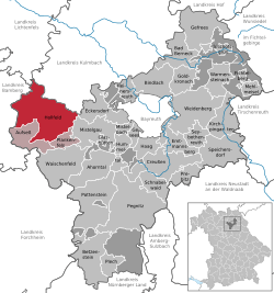 | ||
| Coordinates: 49°56′N 11°18′E / 49.933°N 11.300°ECoordinates: 49°56′N 11°18′E / 49.933°N 11.300°E | ||
| Country | Germany | |
| State | Bavaria | |
| Admin. region | Oberfranken | |
| District | Bayreuth | |
| Government | ||
| • Mayor | Karin Barwisch (Bürgerforum) | |
| Area | ||
| • Total | 81 km2 (31 sq mi) | |
| Elevation | 403 m (1,322 ft) | |
| Population (2017-12-31)[1] | ||
| • Total | 5,027 | |
| • Density | 62/km2 (160/sq mi) | |
| Time zone | CET/CEST (UTC+1/+2) | |
| Postal codes | 96142 | |
| Dialling codes | 09274 | |
| Vehicle registration | BT | |
| Website | www.hollfeld.de | |

Hollfeld is a town in the district of Bayreuth, in Bavaria, Germany.
It is situated 20 km west of Bayreuth, and 30 km east of Bamberg.
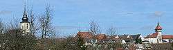
Panorama
Sport
The towns association football club, ASV Hollfeld, experienced its greatest success in 2012 when it qualified for the new northern division of the expanded Bayernliga, the fifth tier of the German football league system, where it played for two seasons until 2014.
Gallery
 Mariä Himmelfahrt
 Gangolfsturm
Villages
 |
 |
 |
 |
 |
 |
 |
| Drosendorf | Fernreuth | Freienfels | Gottelhof | Hainbach | Höfen | Hollfeld |
 |
 |
 |
 |
 |
 |
 |
| Kainach | Krögelstein | Loch | Moggendorf | Neidenstein | Pilgerndorf | Schönfeld |
 |
 |
 |
 |
 |
 |
 |
| Stechendorf | Tiefenlesau | Treppendorf | Weiher | Welkendorf | Wiesentfels | Wohnsdorf |
References
- ↑ "Fortschreibung des Bevölkerungsstandes". Bayerisches Landesamt für Statistik und Datenverarbeitung (in German). September 2018.
External links
| Wikimedia Commons has media related to Hollfeld. |
- Website (German)
This article is issued from
Wikipedia.
The text is licensed under Creative Commons - Attribution - Sharealike.
Additional terms may apply for the media files.