Misema River
| Misema River | |
| River | |
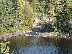 Banks of the Misema | |
| Country | Canada |
|---|---|
| Province | Ontario |
| Region | Northeastern Ontario |
| Districts | Timiskaming, Cochrane |
| Part of | Saint Lawrence River drainage basin |
| Tributaries | |
| - left | Little Misema River |
| Source | Sullivan Lake |
| - location | Ben Nevis Township, Cochrane District |
| - elevation | 375 m (1,230 ft) |
| - coordinates | 48°16′50″N 79°42′03″W / 48.28056°N 79.70083°W |
| Mouth | Blanche River |
| - location | Marter Township, Timiskaming District |
| - elevation | 183 m (600 ft) |
| - coordinates | 47°54′03″N 79°52′38″W / 47.90083°N 79.87722°WCoordinates: 47°54′03″N 79°52′38″W / 47.90083°N 79.87722°W |
 Location of the mouth of the Misema River in Ontario | |
The Misema River is a river in Timiskaming District and Cochrane District in Northeastern Ontario, Canada.[1] It is in the Saint Lawrence River drainage basin and is a left tributary of the Blanche River.
Course
The river begins at Sullivan Lake in geographic Ben Nevis Township, Cochrane District.[2] It exits the lake at the northeast and travels counterclockwise around the Pushkin Hills, part of the Blake River Megacaldera Complex,[3] eventually headng south into Timiskaming District and Misema Lake, where it takes in the left tributary Little Misema River in geographic Katrine Township.[4] It heads south, passes under the former National Transcontinental Railway main line transcontinental railroad and Ontario Highway 66, flows over the Eighty Foot Falls, site of Canadian Hydro Developers' Misema Dam and 3.2 MW hydroelectric powerplant,[5] and reaches its mouth at the Blanche River in Marter Township on the border with Chamberlain to the west. The Blanche River flows via the Ottawa River to the Saint Lawrence River.
Tributaries
- Spring Creek (left)
- McElroy Creek (right)
- Estrangement Creek (left)
- Victoria Creek (right)
- Kinabik Creek (left)
- Little Misema River (left)
See also
References
- ↑ "Misema River". Geographical Names Data Base. Natural Resources Canada. Retrieved 2014-05-15.
- ↑ "Ben Nevis" (PDF). Geology Ontario - Historic Claim Maps. Ontario Ministry of Northern Development, Mines and Forestry. Archived from the original (PDF) on 2016-03-04. Retrieved 2014-05-15.
- ↑ "Pushkin Hills". Ontario Parks. Archived from the original on 2014-04-13. Retrieved 2014-05-15.
- ↑ "Katrine" (PDF). Geology Ontario - Historic Claim Maps. Ontario Ministry of Northern Development, Mines and Forestry. Archived from the original (PDF) on 2014-05-17. Retrieved 2014-05-16.
- ↑ "Canadian Hydro secures agreement for 3.2-MW Misema". Canadian News. HydroWorld.com. 2007-09-01. Retrieved 2014-05-15.
Other map sources:
- Map 15 (PDF) (Map). 1 : 1,600,000. Official road map of Ontario. Ministry of Transportation of Ontario. 2014. Retrieved 2014-05-15.
- Restructured municipalities - Ontario map #3 (Map). Restructuring Maps of Ontario. Ontario Ministry of Municipal Affairs and Housing. 2006. Retrieved 2014-05-15.