Milner, Colorado
| Milner, Colorado | |
|---|---|
| Unincorporated community | |
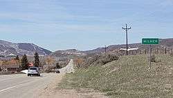 Milner in 2014. | |
| Coordinates: 40°29′05″N 107°01′10″W / 40.48472°N 107.01944°WCoordinates: 40°29′05″N 107°01′10″W / 40.48472°N 107.01944°W | |
| Country |
|
| State |
|
| County | Routt |
| Elevation[1] | 6,522 ft (1,988 m) |
| Time zone | UTC-7 (MST) |
| • Summer (DST) | UTC-6 (MDT) |
| ZIP code[2] | 80487 |
| Area code(s) | 970 |
| GNIS feature ID | 171404 |
Milner is an unincorporated community located in Routt County, Colorado, United States. The elevation is 6,522 feet (1,988 meters) above sea level.[3] Milner lies in the Mountain Time Zone (MST/MDT) and observes daylight saving time. The settlement is located along State Hwy 40 between the nearby communities of Craig and Steamboat Springs.
References
- ↑ "US Board on Geographic Names". United States Geological Survey. 2007-10-25. Retrieved 2008-01-31.
- ↑ "ZIP Code Lookup". United States Postal Service. Archived from the original (JavaScript/HTML) on January 1, 2008. Retrieved April 23, 2014.
- ↑ "Milner, Colorado". Geographic Names Information System. United States Geological Survey. Retrieved 2011-03-07.
External links
Municipalities and communities of Routt County, Colorado, United States | ||
|---|---|---|
| City | 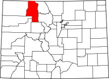 | |
| Towns | ||
| CDP | ||
| Unincorporated communities | ||
| Ghost towns | ||
This article is issued from
Wikipedia.
The text is licensed under Creative Commons - Attribution - Sharealike.
Additional terms may apply for the media files.