Milltown, Montana
| Milltown, Montana | |
|---|---|
| Unincorporated community | |
 Milltown, Montana  Milltown, Montana | |
| Coordinates: 46°52′17″N 113°52′54″W / 46.87139°N 113.88167°WCoordinates: 46°52′17″N 113°52′54″W / 46.87139°N 113.88167°W | |
| Country | United States |
| State | Montana |
| County | Missoula |
| Elevation | 3,287 ft (1,002 m) |
| Time zone | UTC-7 (Mountain (MST)) |
| • Summer (DST) | UTC-6 (MDT) |
| ZIP code | 59851 |
| Area code(s) | 406 |
| GNIS feature ID | 787441[1] |
Milltown is an unincorporated community in Missoula County, Montana, United States. Milltown is located along Interstate 90 and Montana Highway 200 5.5 miles (8.9 km) east of downtown Missoula. The community has a post office with ZIP code 59851.[2][3]
References
- ↑ "Milltown". Geographic Names Information System. United States Geological Survey.
- ↑ United States Postal Service (2012). "USPS - Look Up a ZIP Code". Retrieved 2012-02-15.
- ↑ "Postmaster Finder - Post Offices by ZIP Code". United States Postal Service. Retrieved July 9, 2014.
Municipalities and communities of Missoula County, Montana, United States | ||
|---|---|---|
| City | 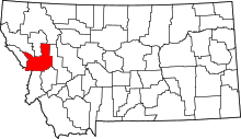 | |
| CDPs | ||
| Unincorporated communities | ||
| Ghost towns | ||
| Indian reservation | ||
| Footnotes | ‡This populated place also has portions in an adjacent county or counties | |
This article is issued from
Wikipedia.
The text is licensed under Creative Commons - Attribution - Sharealike.
Additional terms may apply for the media files.