Milford Track
| Milford Track | |
|---|---|
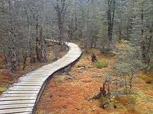
 Trampers on part of Milford Track | |
| Length | 53.5 km (33.2 mi) |
| Location | Fiordland National Park, Southland, New Zealand |
| Designation | New Zealand Great Walk |
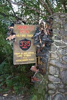
| Trailheads | Glade Wharf in Lake Te Anau, Sandfly Point in Milford Sound |
| Use | Hiking |
| Elevation | |
| Highest point | Mackinnon Pass, 1,140 m (3,740 ft) |
| Lowest point | Sandfly Point, 0 m (0 ft) |
| Hiking details | |
| Season | Summer to Autumn |
| Months | Late October to late April |
| Sights | See below |
| Hazards | Hypothermia, sunburn, high winds, flooding, sandflies, avalanches |
The Milford Track is a widely known tramping (hiking) route in New Zealand – located amidst mountains and temperate rain forest in Fiordland National Park in the southwest of the South Island.
The 53.5 km hike starts at Glade Wharf at the head of Lake Te Anau and finishes in Milford Sound at Sandfly Point, traversing rainforests, wetlands, and an alpine pass.
The New Zealand Department of Conservation classifies this track as a Great Walk and maintains three huts along the track: Clinton Hut, Mintaro Hut and Dumpling Hut. There are also three private lodges and four day shelters available.
The Fastest Known Time (FKT) is currently held by the American Brian Culmo in 6H55'[1]
History
The native Māori people used the Milford Track for gathering and transporting valuable greenstone. There are many Māori legends about the track and the native species found in it.
Coming in from the Milford end, Donald Sutherland and John Mackay were the first European explorers to see what are now known as Mackay Falls and Sutherland Falls, in 1880.[2] At the Lake Te Anau end, Quintin McKinnon was employed to try to find an overland tourist route into Milford Sound, and in 1888 discovered was what is now named Mackinnon Pass; with his route becoming known as the Milford Track. He was the first guide to take walkers from Lake Te Anau to Milford Sound. McKinnon began by guiding tours himself and expanded with a marketing campaign from there. Many parts of the Milford Track are named for McKinnon, including Mackinnon Pass, the highest point of the track (although the spelling is slightly different). He also impressed with his "ability at cooking pompolonas, a type of scone from which one of the guided trip huts takes its name."[3]
In 1901, the government via the Department of Tourist and Health Resorts, and later the Tourist Hotel Corporation assumed administrative control of the track and guided tours until it was sold to a private enterprise in 1990. The track was very famous with women from early on. Some parties consisted of three-quarters females even in the first half of the 20th century.[4]
For a great length of its history, only commercial guided tours had the right to be on the track, but in 1965 a "freedom walk" by 46 members of the Otago Tramping Club led to the opening up to the current system of dual system in 1966[5] with additional huts and facilities for independent walkers created allowing individual, non-guided tours on the route. Today, a quota system allows approximately half the capacity of the track to be used by guided tours, while the other half is undertaken by people walking on their own or in informal groups. The two types of walker use separate systems of huts.
In 1992, sports organiser Robin Judkins planned a mountain marathon to be held on the Milford Track – the Milford Mountain Marathon. The event was most contentious and caused much angst, including death threats, physical attacks and anonymous phone calls. Judkins fought a very public fight with politicians and conservationists, including Gerry McSweeney, and obtained all the approvals and permits, but cancelled the event.[6]
Due to its popularity and the limited facilities available for overnighting (camping is not permitted), the track remains heavily regulated.
Access
Unlike most of the other Great Walks the Milford Track has no direct carpark access, and hence trampers require boat transport to the start of the track from Te Anau Downs to Glade House (the southern start of the track). There is also foot access to the start via the Dore Pass Route (10.5 km one way) although this is an advanced track and not recommended for most walkers.[7] At the northern end of the track at Sandfly Point another boat is required to take trampers back to Milford Sound. The north to south option still involves both boats but can only be done during the winter season.
Summer peak season
During the summer peak season of late October to late April, access to the trail is highly regulated. Walkers must complete the track in four days, travelling only in the northward direction. Camping is prohibited on the trail. Walkers can tramp the track independently, or as part of a more expensive guided walk with a guide company. A maximum of 90 walkers can start the trail per day (40 Independent, and 50 Guided). Usually these 90 places are booked out for many months in advance, despite the high cost of the guided walks.
Due to the one-way ticket system and limited hut capacities, trampers need to keep moving even during bad weather. During periods of especially heavy flooding, the DOC regularly calls in helicopters which fly trampers over flooded sections of the track at no further charge.[8]
Independent tramping
If hiking independently, each night must be spent in a hut owned and maintained by the Department of Conservation. The huts for independent walkers have basic facilities, which include bunk areas, restrooms, and cooking facilities; walkers have to carry their own equipment and food.
Guided tramp
On a guided walk, walkers stay in lodges owned and operated by Ultimate Hikes. These lodges have facilities such as hot showers, catered meals, beds, lounge areas, electric lights, and drying rooms. Guided trampers need only carry clothing, toiletries, their sheets, and lunch while on the trail. Guides walk with trampers, providing as little or as much assistance as required.
Off Season
During the off season from May to mid-October, the track is essentially unregulated, and can be tramped in either direction, over any number of days. It is however much more difficult and dangerous tramping in this season, as facilities at huts are removed, some bridges (up to 10) are removed to prevent avalanche damage. Advice to those contemplating using the track during the winter includes:
- "...there are 57 avalanche paths in the area, some of which may cross the track and bring avalanche debris to the valley floor.... you must be competent at crossing large, swift, icy rivers...Mackinnon Pass is not marked and is often covered in deep snow..."[9]
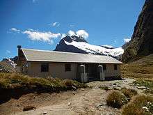
Huts
| Name | Description | Distance | Coordinates |
|---|---|---|---|
| DOC Huts | |||
| Clinton Hut | Night 1, shortly before Clinton Forks, after the marsh boardwalk | 5.0 km | 44°54′18.23″S 167°54′6.63″E / 44.9050639°S 167.9018417°E |
| Mintaro Hut | Night 2, Situated just before the start of the climb up to Mackinnon Pass | 21.5 km | 44°48′37.61″S 167°46′34.84″E / 44.8104472°S 167.7763444°E |
| Dumpling Hut | Night 3, A few kilometers after Quintin Lodge | 35.5 km | 44°46′07.18″S 167°45′56.35″E / 44.7686611°S 167.7656528°E |
| Private Lodges (for guided walkers) | |||
| Glade House | Night 1, just 1.6 km from track start. | 1.6 km | 44°55′18″S 167°55′43″E / 44.921797°S 167.928721°E |
| Pompolona Lodge | Night 2, In a forested part of the Clinton Canyon, just after Bus Stop Shelter. | 17.5 km | 44°50′15″S 167°48′03″E / 44.837485°S 167.80094°E |
| Quintin Lodge | Night 3, At the turnoff to Sutherland Falls, on the Roaring Burn. | 32.5 km | 44°47′29″S 167°45′11″E / 44.791348°S 167.752985°E |
| Day Use Shelters | |||
| Hirere Shelter | Just after Clinton Forks | 44°52′12.48″S 167°50′32.13″E / 44.8701333°S 167.8422583°E | |
| Bus Stop Shelter | Just before Pompolona Lodge | 44°50′25.73″S 167°48′16.08″E / 44.8404806°S 167.8044667°E | |
| Pass Hut | Located on the summit of Mackinnon Pass | 44°48′11.58″S 167°46′33.55″E / 44.8032167°S 167.7759861°E | |
| Boatshed Hut | Just before Mackay Falls | 44°44′20.33″S 167°48′11.18″E / 44.7389806°S 167.8031056°E | |
Sights
| Name | Description | Location |
|---|---|---|
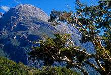
| Mackinnon Pass | A spectacular main-divide pass surrounded by glacier encrusted mountains | 44°48′4.8″S 167°45′58.57″E / 44.801333°S 167.7662694°E |
| Sutherland Falls | Tallest waterfall in NZ at 580 m, continuously fed by Quill Lake | 44°48′.8028″S 167°43′48.77″E / 44.800223000°S 167.7302139°E |
| Nicholas Cirque | Ring of glacial mountains at the head of the valley that is followed when heading northbound to the Mackinnon Pass | 44°48′S 167°45′E / 44.800°S 167.750°E |
| Mackay Falls & Bell Rock | Bell Rock was hollowed out by Mackay Falls and then turned upside down. It is possible to stand in the hollowed out part, which is over 4 m high inside | 44°43′52.29″S 167°47′25.40″E / 44.7311917°S 167.7903889°E |
| Giant Gate Falls | Last major waterfall on the Milford Track heading northbound | 44°42′13.96″S 167°51′9.46″E / 44.7038778°S 167.8526278°E |
| Lake Ada | A lake created by a landslide across the Arthur River[10] | 44°42′30.68″S 167°51′27.56″E / 44.7085222°S 167.8576556°E |
| Milford Sound | World famous for its spectacular sheer cliffs lining the mirror-like fjord | 44°36′55.12″S 167°51′43.84″E / 44.6153111°S 167.8621778°E |
| Lake Te Anau | Created by glacial action, the lake is the second largest body of fresh water in New Zealand and is surrounded by mountains including the Kepler and Murchison Mountains which rise 1,400 m above the surface of the lake. | 44°56′24.22″S 167°54′43.77″E / 44.9400611°S 167.9121583°E |
See also
References
- ↑ "'Great Walks' - NZTRAILRUN". NZTRAILRUN. Retrieved 2017-03-22.
- ↑ Parham, W. T. "Story: Sutherland, Donald". Te Ara The Encyclopedia of New Zealand. Retrieved 24 May 2015.
- ↑ History of the Milford Track at NZ Department of Conservation.
- ↑ The Finest Walk In The World - information and history book provided in the Milford Track huts, New Zealand Department of Conservation
- ↑ "Celebrating the first Milford ‘Freedom Walk’"
- ↑ McKerrow, Bob; Woods, John (1994). Coast to Coast: The Great New Zealand Race. Christchurch, New Zealand: Shoal Bay Press. p. 23. ISBN 978-0-908704-22-4.
- ↑ "Dore Pass Route". Department of Conservation. Retrieved 24 May 2015.
- ↑ "More than 170 airlifted across Milford Track". The New Zealand Herald. NZPA. 7 May 2009. Retrieved 25 October 2011.
- ↑ "Milford Track: Winter tramping", DOC
- ↑ "Lake Ada, Southland - NZ Topo Map". NZ Topo Map. Retrieved 2018-03-31.
External links
| Wikivoyage has a travel guide for Milford_Track. |