Routeburn Track
| Routeburn Track | |
|---|---|
 Key Summit as viewed from track | |
| Length | 32 km (20 mi) |
| Location | Fiordland National Park & Mount Aspiring National Park, New Zealand |
| Designation | New Zealand Great Walk |
| Trailheads | Routeburn Shelter, The Divide |
| Use | Tramping, Trail running |
| Elevation | |
| Highest point | near Harris Saddle 1,300 m (4,300 ft) |
| Lowest point | Routeburn Shelter, 477 m (1,565 ft) |
| Hiking details | |
| Season | Summer to autumn |
| Months | Late October to late April. Possible to walk in winter months too, but for experienced hikers only |
| Sights | Alpine views, lakes, forests, tussocklands, rivers, waterfalls |
| Hazards | Hypothermia, sunburn, high winds, rocks, snow, rain & avalanche risks[1] |
| Surface | dirt, rock |
| Website | Department of Conservation |
The Routeburn Track is a world-renowned, 32 km tramping (hiking) track found in the South Island of New Zealand.[2] The track is usually completed by starting on the Queenstown side of the Southern Alps, at the northern end of Lake Wakatipu, and finishing on the Te Anau side, at the Divide, several kilometres from the Homer Tunnel to Milford Sound.
The New Zealand Department of Conservation classifies this track as a Great Walk and maintains four huts along the track: Routeburn Flats Hut, Routeburn Falls Hut, Lake Mackenzie Hut, and Lake Howden Hut; in addition there is an emergency shelter at Harris Saddle. The track overlaps two National Parks; the Mount Aspiring National Park and Fiordland National Parks with the border and highest point being the Harris Saddle. Access to another tramping area called the Greenstone and Caples Tracks is from Lake Howden Hut near The Divide.
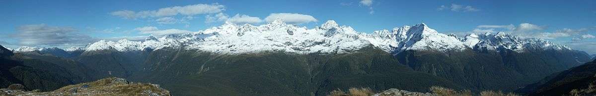
This area gets much less rain than the Milford Sound, and the forests are very different, especially on the eastern side of the saddle, which due to less rainfall is predominantly made up of New Zealand red beech and mountain beech, with relatively few ferns. The track spends a long time on the high ridges around Harris Saddle, with great long-distance views in many directions. The track has a long history of use dating back to the 1880s.
Tramping
Access to the Routeburn Track is not as tightly controlled as the Milford Track. Camping is allowed, though both huts and camping spaces must be booked in advance during peak season. There is a surcharge for non-ticket holders. There is a choice of which direction to go, and which huts to stay in. On the western side, almost everyone stays at the Lake Mackenzie Hut, but on the eastern side, one can stay at the Falls Hut or Flats Hut. The Falls Hut is more popular, since staying there breaks up the climb to the saddle better, especially coming from the east. Camping is not allowed at Falls Hut. In the winter, the Falls Hut is commonly used as a ski touring base for easy access into the Serpentine Range and beyond.
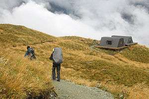
As it is a relatively short track, much of the Routeburn Track is also accessible to day hikers. Key Summit (918m), on the western end is the site of a popular viewpoint and nature walk not far from the roadway, and the return to the Routeburn Flats hut are both commonly done in a day.
Because you usually tramp the track from one end and finish it at the other transport can be challenging. This is because there is a 5-hour drive in between each end meaning it is important to plan your trip. Transport options include bus, hitchhiking, car relocation or the more expensive helicopter option.[3] Some people get around this by doing a key swap with another walker going in the opposite direction.
Track Profile
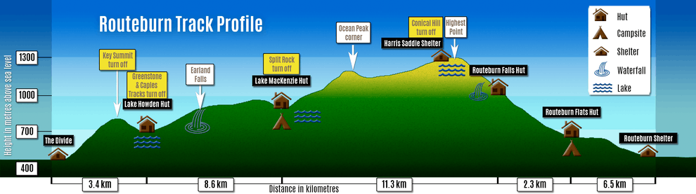
The route
Starting at Routeburn Road end, the track crosses a suspension bridge and starts as a gentle sidle up the true left hand side of the Routeburn River. The well graded track crosses sugarloaf stream (start/finish of the classic five pass tramp) and the Bridal Veil waterfall and leads to a steeper climb that goes above the gorge to Forge Flats, the site of an early blacksmith camp. The valley opens up soon after this point, re-crosses the Routeburn and heads towards the Routeburn flats.
Leaving the Routeburn Flats hut, the track climbs steadily towards the Routeburn falls Hut, passing Eagle Bluff and Emily creek, to the site of a major slip in 1987. This slip has cleared the beech forest from around the track affording views back down the Routeburn as well as up the Routeburn (north branch) towards Mt. Somnus (2293m) and Mt Momus (2148m).
Past the Routeburn Falls hut, the track becomes narrower and more technical as it climbs past Lake Harris. Passing under bluffs as it sidles around Lake Harris there is a view up 'the valley of trolls' towards Lake Wilson (the source of the Routeburn) and the Serpentine Range.
Above Lake Harris, the track arrives at the Harris shelter. The popular side trip to Conical Hill (1515m) is commonly done from the shelter, and offers a 360 degree view of the area. From the saddle (1255m), the track traverses southwards along the Hollyford face, with expansive views out to Martins Bay and the Tasman Sea, before a descent of a steep series of zig-zags to Lake Mackenzie Hut.
From Lake Mackenzie, the track crosses a small flat before climbing to the bushline. It then gradually descends past the 'Orchard', an open grassy area dotted with ribbonwood trees, to the Earland Falls (178m high). The route passes under the falls but in times of heavy flow an alternative route exists dropping below the falls to a small bridge. The track continues its gradual descent down to Howden Hut. From here the track branches off towards the Greenstone and Caples Tracks which create a semi-circuit back towards Glenorchy, the Routeburn continuing past Key Summit to The Divide road end and the end of the track.

In media, news, and popular culture
The Routeburn Track was named one of the top eleven trails in the world by the National Geographic Adventure Magazine in May 2005.
No filming was done for The Lord of the Rings trilogy on the track itself, but the Dart River Valley just north of Glenorchy and before the track starts, was the scene for Isengard.
One of Air New Zealand's A320 safety videos starred Bear Grylls and the video was filmed on the Routeburn track.
Paul Theroux, the American travel writer, described his hike on the Routeburn track in Chapter 2 of his 1992 book, "The Happy Isles of Oceania."
There is an annual mountain run the Routeburn Classic along the Routeburn track (approx 32 km) usually held in April each year that is completed in times of 3–9 hours depending on individual ability. Often the fastest runners complete the entire track in under three hours which is much faster than the 3 days the average tramper takes to complete the track.
Deaths
In March 2008 an Israeli tourist went missing on the track and her body was later found near Roaring Creek having wandered off track for an unknown reason.[4]
In July 2016, a Czech male hiker fell and died while hiking the track; his female partner sheltered at the Lake Mackenzie Huts for a month before she was rescued.[5][6][7]
In May 2018 a 68-year-old man died on the track from a "medical event". [8]
Huts and Shelters
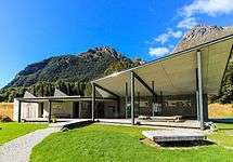 Routeburn Shelter
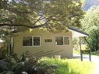 Routeburn Flats Hut
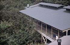 Routeburn Falls Hut
 Harris Saddle Shelter
 Lake Mackenzie Hut
 Lake Howden Hut
.jpg) The Divide Shelter
The Divide Shelter
Birdlife
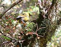
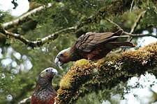
There are a variety of New Zealand native birds to be seen on and near the track. Parrots like the kaka and kea can often be seen and heard and are quite large in comparison to the yellow-crowned parakeet. Often seen are the common and friendly South Island robin and fantail. Smaller birds that are conspicuous are the bellbird, grey warbler, brown creeper, South Island tomtit and the rare yellowhead. Hard to see is the tiny rifleman and New Zealand's smallest bird Rock Wren .[9]


See also
References
- ↑ "Routeburn Track". tramper.co.nz. New Zealand Tramper. Retrieved 3 October 2014.
- ↑ "ROUTEBURN TRACK". Department of Conservation. Retrieved 10 April 2015.
- ↑ "The Routeburn Heli Run". Destination Queenstown. Retrieved 10 April 2015.
- ↑ Cannan, Dave. "Tourist's family visits death site". Otago Daily Times. Retrieved 22 February 2017.
- ↑ "Czech tramper dead on Routeburn Track, partner rescued after month in hut (video)". Stuff (Fairfax). 25 August 2016.
- ↑ "Woman survives in remote hut for a month after partner's hiking death". CNN. 25 August 2016. Retrieved 25 August 2016.
- ↑ "Memorial plaque on Routeburn Track to commemorate Czech tramper". Stuff (Fairfax). 22 January 2017.
- ↑
- "Man dies on South Islands' Routeburn Track". Stuff (Fairfax). 12 May 2018.
- ↑ "The Routeburn Track". ultimatehikes.co.nz. Ultimate Hikes. Retrieved 3 October 2014.
External links
| Wikivoyage has a travel guide for Routeburn Track. |
| Wikimedia Commons has media related to Routeburn Track. |
Coordinates: 44°43′37″S 168°10′13″E / 44.726954°S 168.170337°E