Mid and East Antrim
Coordinates: 54°49′41″N 6°04′41″W / 54.828°N 6.078°W
| Mid and East Antrim Irish: Lár- agus Oir-Aontroime Ulster Scots: Mid an East Anthrim | |
|---|---|
| District | |
 | |
| Sovereign state | United Kingdom |
| Constituent country | Northern Ireland |
| Status | District |
| Incorporated | 1 April 2015 |
| Government | |
| • Type | District council |
| • Body | Mid and East Antrim Borough Council |
| Area | |
| • Total | 404 sq mi (1,046 km2) |
| Population (mid-2017 est.) | |
| • Total | 138,200 |
| • Density | 340/sq mi (130/km2) |
| Time zone | UTC0 (GMT) |
| • Summer (DST) | UTC+1 (BST) |
| Website | http://www.midandeastantrim.gov.uk/ |
Mid and East Antrim is a local government district in Northern Ireland. The district was created on 1 April 2015 by merging the Borough of Ballymena, the Borough of Larne and the Borough of Carrickfergus. The local authority is Mid and East Antrim Borough Council.
Geography
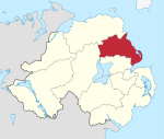
The district is wholly located in County Antrim, and stretches from the River Bann in the west to the Antrim Coast, taking in the southern part of the Antrim Coast and Glens Area of Outstanding Natural Beauty, as well as the major towns of Ballymena and Carrickfergus, and the important port of Larne. The district has a population of 138,200.[1] The name of the new district was announced on 17 September 2008.
History
Mid and East Antrim Borough Council replaced Ballymena Borough Council, Carrickfergus Borough Council and Larne Borough Council. The first election for the new district council was originally due to take place in May 2009, but in April 2008, Shaun Woodward, Secretary of State for Northern Ireland announced that the scheduled 2009 district council elections were to be postponed until 2011.[2] The first elections took place on 22 May 2014 and the council acted as a shadow authority until 1 April 2015.