Ards and North Down
Coordinates: 54°33′43″N 5°38′13″W / 54.562°N 5.637°W
| Ards and North Down Irish: An Aird agus An Dún Thuaidh Ulster Scots: Tha Airds an North Doon | |
|---|---|
| District | |
 | |
| Sovereign state | United Kingdom |
| Constituent country | Northern Ireland |
| Status | District |
| Incorporated | 1 April 2015 |
| Government | |
| • Type | District council |
| • Body | Ards and North Down Borough Council |
| Area | |
| • Total | 177.9 sq mi (460.8 km2) |
| Population (mid-2017 est.) | |
| • Total | 160,100 |
| • Density | 900/sq mi (350/km2) |
| Time zone | UTC0 (GMT) |
| • Summer (DST) | UTC+1 (BST) |
| Website | http://www.ardsandnorthdown.gov.uk/ |
Ards and North Down is a local government district in Northern Ireland. It was created on 1 April 2015 by merging the Borough of Ards and the Borough of North Down. The local authority is Ards and North Down Borough Council.
Geography
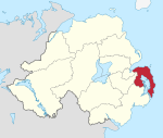
The new district is in the East of Northern Ireland, covering the Ards Peninsula, most of Strangford Lough and the southern shore of Belfast Lough. It has an estimated population of 160,100.[1] The original name of the new district was recommended on 17 September 2008.[2]
Council
Ards and North Down Borough Council replaces Ards Borough Council and North Down Borough Council. The first election for the new district council was originally due to take place in May 2009, but on April 25, 2008, Shaun Woodward, Secretary of State for Northern Ireland, announced that the scheduled 2009 district council elections were to be postponed until 2011.[3] The first elections took place on 22 May 2014 and the council will act as a shadow authority until 1 April 2015.
At a meeting of the shadow authority on 15 December 2014, councillors voted in favour of changing the council’s name to East Coast Borough Council, and to submit an application to the Department of the Environment to change the name with effect from 1 April 2015.[4] However, the council's website launched on 1 April 2015 refers to the new council as "Ards and North Down Borough Council", and this name has continued in use.
See also
References
- ↑ "Population Estimates for UK, England and Wales, Scotland and Northern Ireland, Mid-2017". Office for National Statistics. 28 June 2018. Retrieved 28 June 2018.
- ↑ "Provisional Recommendations of the Local Government Boundaries Commissioner for Northern Ireland". LGBC. Archived from the original on 2008-09-20. Retrieved 2008-09-26.
- ↑ Northern Ireland elections are postponed, BBC News, April 25, 2008, accessed April 27, 2008
- ↑ "Archived copy". Archived from the original on 2015-01-12. Retrieved 2016-01-07.