Mexican Federal Highway 5
| ||||
|---|---|---|---|---|
| Carretera Federal 5 | ||||
| Route information | ||||
| Maintained by Secretariat of Communications and Transportation | ||||
| Length | 200 km (124 mi) | |||
| Major junctions | ||||
| North end |
| |||
|
| ||||
| South end | San Felipe | |||
| Highway system | ||||
|
Mexican Federal Highways
| ||||

Federal Highway 5 (Spanish: Carretera Federal 5, Fed. 5 ) is a free part of the federal highways corridors (Spanish: los corredores carreteros federales), and follows the northeast length of the state of Baja California from the US-Mexico border in Mexicali at the northern point at San Felipe in the south.[1][2] The highway is entirely inside the Mexicali Municipality. However, a state highway from San Felipe to Puertecitos (Ensenada Municipality) is usually considered part of Fed. 5. From San Felipe to the south, the road follows the seacoast of the Gulf of California. It has a total length of 400 km. but only 370 km from Mexicali to San Luis Gonzanga are paved. The 30 km beyond San luis Gonzanga to Chapal is to be paved.
Route description
The road begins in the border city of Mexicali at the western border crossing. It has four lanes from there for about km 80.[3] At this point it becomes a two-lane highway (with little or no shoulder in most areas) until km 160, about 18 km (11 mi) south of the junction with Fed. 3, and about 40 km (24 mi) north of San Felipe. From there, the highway is a broad, divided, four-lane highway with a median and ample shoulders, until it ends in San Felipe.
The new highway improvement segments being constructed from San Felipe to the north and Mexicali to the south are on a raised base so that roadway dips caused by the natural undulation of the landscape, a form of drainage, are replaced by drainage culverts covered by the highway. Vehicles no longer have to ford storm water passing over the roadway. The resulting highway is less susceptible to erosion.
The interchange with Fed. 3 eliminates there the need for cross traffic driving.
Earthquake damage and repairs
The epicentre (32°15'32"N, 115°17'13.2"W) of the magnitude 7.2 earthquake on April 4th, 2010 (2010 Baja California earthquake) is about 3 km east of the highway.[4] Repairs on the highway began nearly immediately. From km 20 to km 38, SCT (Secretaría de Comunicaciones y Transportes) contractors re-levelled the road and filled cracks.
State Highway Extension
The state route that starts in San Felipe and continues to Puertecitos is a natural extension of Fed. 3. It is an undivided, two-lane highway that has some rough spots and has many significant dips or fords where the highway meets normally-dry steams. One of the largest is labelled on the road in both directions as the "OH SHIT DIP." The continuation of Baja 5 to Gonzaga Bay was paved in 2015. Survey crews are currently working on the final 20 mile section of the extension to the Fed. 1 at Chapala.
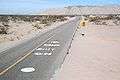 Road markings south of the dip with the vado to the north beyond on Fed. 5.
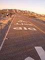 The markings on the other side of the road with only the mountains to the north in the background
Baja California
- Mexicali intersection with Fed. 2
- El Chinero intersection with Fed. 3 north of San Felipe
- Puertecitos
References
- ↑ "Atlas por Entidad Federativa". Secretaría de Comunicaciones y Transportes de México. Archived from the original on February 18, 2009. Retrieved August 28, 2009.
- ↑ "Baja California" (PDF). Secretaría de Comunicaciones y Transportes de México. Archived from the original (PDF) on May 18, 2012. Retrieved December 2, 2011.
- ↑ "Mexicali to San Felipe via Highway 5". sanfelipe.com.mx. Retrieved November 28, 2011.
- ↑ "Magnitude 7.2 - BAJA CALIFORNIA, MEXICO". United States Geological Survey. Archived from the original on April 7, 2010. Retrieved April 10, 2010.
| Highways |
|
|---|---|
| Toll roads | |
| Former highways | |
| Unumbered Highways | |