Mesquite, Borden County, Texas
| Mesquite, Texas | |
|---|---|
| Ghost Town | |
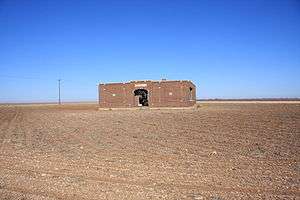 Mesquite school (abandoned) | |
 Mesquite  Mesquite | |
| Coordinates: 32°52′13″N 101°37′49″W / 32.87028°N 101.63028°WCoordinates: 32°52′13″N 101°37′49″W / 32.87028°N 101.63028°W | |
| Country |
|
| State |
|
| County | Borden |
| Physiographic region | Llano Estacado |
| Founded | 1905 |
| Elevation[1] | 2,966 ft (904 m) |
| Time zone | UTC-6 (Central (CST)) |
| • Summer (DST) | UTC-5 (CDT) |
| Area code(s) | 806 |
| Website | Handbook of Texas |
Mesquite is a former town in Borden County, Texas, United States. From its inception, Mesquite remained a rural farming community. A school, established in 1905, served the area until 1952, after which the building appears to have been abandoned. Today all that remains at the site of Mesquite are a Church of Christ, and the abandoned schoolhouse.[2] The rest of the town appears to have been subsumed by private farms for crop land.
Geography
Mesquite is located on Farm to Market 1054, east of US Route 87 and north of US Route 180. The nearest large community is Lamesa, about 15 miles (24 km) to the southwest.
See also
References
- ↑ "Mesquite". Geographic Names Information System. United States Geological Survey.
- ↑ Davis, Charles G. "Mesquite, TX (Borden County)". Handbook of Texas Online. Retrieved February 3, 2011.
External links
- Brief information on Mesquite
- U.S. Geological Survey Geographic Names Information System: Mesquite, Texas (Borden County)
- Photos of West Texas and Eastern New Mexico
Municipalities and communities of Borden County, Texas, United States | ||
|---|---|---|
| Census-designated place | 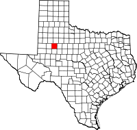 | |
| Other unincorporated community | ||
| Ghost town | ||
This article is issued from
Wikipedia.
The text is licensed under Creative Commons - Attribution - Sharealike.
Additional terms may apply for the media files.